DPO Observations: Chapter 9, Sections 9.6, 9.7, 9.8
DPO Dynamics: Chapter 7, Section 7.10Additional resources:
WOCE Hydrographic Programme Atlas for the Atlantic Ocean: many vertical sections, property plots and maps.
Abyssal circulation dynamics. See text in DPO chapter 7.10. We did not cover this topic in the dynamics lectures. Salient features: driven by localized sources of deep water and general upwelling within the deep layer (Stommel and Arons, 1961). The upwelling creates a Sverdrup-type response in the interior, with upwelling causing poleward flow. This is connected to the localized deep source by the Deep Western Boundary Current. Thus paradoxically, most of the deep gyres appear to flow towards the high latitude sources of deep water.
The deep upwelling can only be accomplished through diapycnal diffusion of heat downwards. (Also freshwater diffusion must be important.) The vertical structure resulting from the upwelling depends on the size of the diapycnal diffusivity.
Abyssal circulation. The circulation is depicted in maps from Reid (1994). In addition to the deep expression of the principal gyres, the abyssal circulation is dominated by "Deep Western Boundary Currents" that feed the interior deep circulation, which is largely cyclonic in the individual deep basins. There are DWBCs leading northward from the Antarctic and southward from the Labrador Sea and Nordic Sea overflow regions.
North Atlantic Deep Water. There are five sources of NADW, classified in a bit of an oversimplification as: Antarctic Intermediate Water, Antarctic Bottom Water, Mediterranean Overflow Water, Labrador Sea Water and Nordic Sea Overflow Water. Two of these are the original southern sources, and the other three are the North Atlantic sources.
The deep circulation of the Atlantic involves flow of waters from the southern hemisphere into the North Atlantic, modification and convection of these waters in the North Atlantic and its adjacent seas, and outflow in a thick deep layer. This deep layer affects the world ocean, where it can be tracked through its high salinity signature since the North Atlantic is the most saline of all the oceans. The deep layer flowing out of the North Atlantic is called North Atlantic Deep Water and is notable for its vertical salinity maximum, vertical oxygen maximum (actually two) and vertical nutrient minima.
Inflow to the North Atlantic occurs in two layers - a relatively warm one and a cold one, sandwiching the outflowing NADW. The upper layer is composed of thermocline and Antarctic Intermediate Water (evidenced by a salinity minimum in the vertical at about 800 m depth, resulting from its source at the sea surface near the tip of South America where surface salinity is low). The AAIW can be tracked as a salinity minimum up to the subtropical gyre in the North Atlantic. Because the North Atlantic is a very well-ventilated ocean, from top to bottom, it has lower nutrients throughout its depths compared with other oceans. AAIW comes from the South Atlantic where nutrients are higher, and it so happens that it can be tracked through the Gulf Stream and on up into the subpolar North Atlantic through its silica, which is slightly higher than the North Atlantic silica.
The other southern source for NADW is at the ocean bottom - the Antarctic Bottom Water. This is actually deep water (not bottom water) from the South Atlantic sector of the Antarctic. (The true bottom waters, formed in the Weddell Sea and Ross Sea, do not escape very far northward, mainly because of topography that confines them. The Antarctic Bottom Water in the South and North Atlantic is essentially the same as what we call Circumpolar Deep Water in the Pacific and Indian Oceans.) AABW is apparent as a cold, lower salinity bottom layer and extends northward in the North Atlantic up to the Gulf Stream latitude. It upwells into the southward-flowing NADW layer above it (and hence does not reach the sea surface).
In the North Atlantic, the components of NADW are formed at three sites, all involving intermediate depth convection: inside the Mediterranean Sea, in the Labrador Sea and in the Greenland Sea.
The Mediterranean Sea is connected to the North Atlantic through the narrow Strait of Gibraltar. Flow is into the Mediterranean at the sea surface in the Strait. Within the Mediterranean there is large evaporation and cooling and production of dense water. This flows out into the North Atlantic at the bottom of the Strait. The resulting Mediterranean Water (or Mediterranean Outflow or Overflow Water) in the North Atlantic is found at mid-depth and is marked by its salinity maximum both in the vertical and in the horizontal along isopycnals. The MOW forms the upper part of the North Atlantic Deep Water. (In the tropical Atlantic, Wust referred to the salinity maximum core of the NADW as Upper North Atlantic Deep Water - UNADW clearly originates as MOW.) MOW properties at Gibraltar are 13C, 38.45 psu and 29.07 sigma theta. This is actually denser than the bottom water of the North Atlantic. As the plume of MOW exits Gibraltar, it moves to the north (boundary to the right, in the Kelvin wave sense) and down the slope. Vigorous entrainment as it moves down the slope reduces its high salinity and density. It finally equilibrates after mixing at a depth of about 1000 m. (Figures from Ochoa and Bray, Zenk, Reid (1994) showing salinity distribution at about 1000 m, outflow characteristics.)
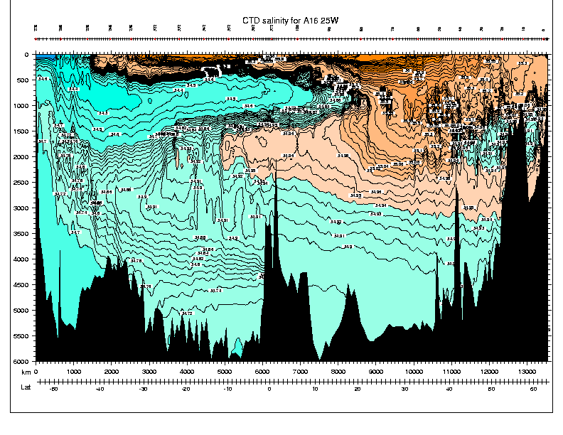
Salinity at 25W showing salinity maximum of MOW (30-40N at 1000m), salinity minimum of
LSW (40-60N at 1500-2000m). Also - salinity minimum of AAIW (south of 20N
at 500-1000m) and overall salinity maximum of NADW (south of 20N and
1500-3000m).
Salinity at 24N showing salinity maximum of MOW in the east at 1000m.
The two northern sources of NADW are formed from surface waters that flow northward in the Gulf Stream and North Atlantic Current and then eastward and northward in the subpolar region. These surface waters cool and freshen along this path towards the ultimate intermediate-depth convection regions. Cooling of the subpolar surface waters creates very thick mixed layers in the subpolar gyre. These thick layers are called Subpolar Mode Water, in analogy with the Subtropical Mode Water of the subtropical gyres. SPMW temperature range from about 14C near the North Atlantic Current, to 8C where SPMW enters the Norwegian Sea, to 4C where SPMW enters the Labrador Sea. (Figure from McCartney and Talley, 1982.)
The two northern parts of NADW are Labrador Sea Water and Nordic Sea Overflow Water. (The latter is also referred to by its three separate components resulting from overflows at three separate sites into the North Atlantic, and also sometimes as Greenland-Iceland-Norwegian Sea overflow water or GIN-Sea overflow.)
Labrador Sea Water is formed in the western Labrador Sea through convection to about 1500-2000 meters in late winter. This forms a relatively homogeneous water mass within the Labrador Sea. Much attention has been focused in recent years on both the formation of LSW and on its changing properties (temperature changing from 3.5C to about 2.9C on decadal time scales). Labrador Sea Water spreads out into the North Atlantic, filling both the subpolar gyre and entering the subtropical gyre. Within the subpolar gyre, it is marked by a salinity minimum in the vertical. Within both the subpolar and subtropical gyres it is marked by an oxygen maximum in the vertical. Within both gyres it is also marked by a thickness maximum resulting from its convective source. (Instead of thickness, the quantity that is often mapped is called potential vorticity, which we have not discussed in this class. Potential vorticity is inversely proportional to the thickness of the layer and proportional to the Coriolis parameter; PV is conserved following flow, essentially like angular momentum, whereas thickness is not conserved.) (Figures from McCartney and Talley, 1982; Lazier, 1993; Talley and McCartney, 1982; Lavender et al., 2000.)
LSW moves southward along the western boundary of the North Atlantic as the upper part of the Deep Western Boundary Current, above the denser water that originates in the Nordic Seas. The oxygen maximum of the LSW persists to the tropical Atlantic where Wust referred to it as "Middle North Atlantic Deep Water". (Figure from Wust.)
Potential Temperature at 47N,
Salinity at 47N,
Potential vorticity at 47N
Salinity at 47N as a function of density rather than depth.
The densest part of the NADW is formed through convection in the Greenland Sea offshore of the East Greenland Current and ice edge. This portion of NADW has many different names, but we will call it Nordic Sea Overflow Water. Flow into the Nordic Seas is in the Subpolar Mode Water layer, east of Iceland. The Greenland Sea convection is usually to intermediate depths, and is colder and denser than convection in the Labrador Sea, hence producing the denser part of the NADW. (Experiments in recent years, involving acoustic tomography to track convection through the winter, have examined the Greenland Sea convection. Much attention has been given to climatic variations in convection in the Greenland Sea.) (Figures from Morawitz et al., 1996.)
Outflow of the dense NSOW occurs in three locations along the Greenland-Faroe ridge: through Denmark Strait (between Greenland and Iceland), across the Iceland-Faroe ridge (between Iceland and the Faroe Islands), and through the Faroe-Shetland channel (between the Faroe and Shetland Islands). All three locations are relatively shallow sills. The dense water flowing southward over the sills plunges downward in plumes, entraining (mixing with) surrounding water in the process. This modifies the properties of the NSOW as it enters the North Atlantic. (Figures from Dickson and Brown.)
The deep part of the NADW thus produced as NSOW fills the western North Atlantic through the lower part of the Deep Western Boundary Current. The DWBC crosses under the Gulf Stream. The presence of the DWBC is not obvious in isopycnal slopes crossing the Gulf Stream. Now that we have mapped many different properties, the DWBC is apparent as a core layer of higher oxygen. The DWBC was predicted in a theory by Stommel and Arons, and then its presence was detected through the earliest use of deep tracked floats (Swallow and Worthington). (Figures from Jenkins, Reid, and Swallow and Worthington.)
The DWBC continues to the South Atlantic. One feature of the DWBC is that is exhibits recirculations to the north on its offshore side. These spread the DWBC waters into the ocean interior. (Cartoon from McCartney.)
Transports for the various components of the NADW overturn have been computed. The net transport involved in the overturn is 15 to 20 Sv. (Figures from Schmitz, and from Schmitz and McCartney)
1. What is a water mass?
2. What are the major water masses of the North Atlantic? What are their sources and what distinguishes them? How is each one formed?
3. What are the five components of North Atlantic Deep Water? Where does each originate? Describe the way each enters the deep North Atlantic. Where does each become a part of the "NADW"? Is the NADW a completely undifferentiated, homogeneous water mass?
4. Locate the Antarctic Intermediate Water in the Atlantic using its most common characteristic. How far north is it easily discernible?
5. Locate deeper waters of Antarctic origin on meridional sections extending to the north. What properties are used to differentiate these from Deep Waters moving south?
6. Where are the saltiest and the freshest intermediate and deep waters found? (e.g. look at different isopycnals and note the extremes)
7. Where do low salinity intermediate waters form in the northern hemisphere? Contrast the formation of the N. Atlantic and N. Pacific intermediate waters.
8. Where is there active and relatively deep (>1000m) convection in the North Atlantic and adjacent seas? Where is shallower convection (200-1000m) found in the North Atlantic?
9. Where does the densest water form in the northern hemisphere?
10. Why is the Mediterranean Sea important even though the net exchange of water with the N. Atlantic is quite small?
11. What do we mean by "age" of water? What is the approximate difference in age between deep waters of the N. Pacific and deep waters of the N. Atlantic?
12. Explain the 36N meridional transport diagram in Roemmich and Wunsch in terms of water masses and the direction they are moving on average.
13. Why does the deep western boundary current in the North Atlantic go the opposite direction from the Gulf Stream?