Lynne D. Talley*, Vyacheslav Lobanov+, Alexey Shcherbinin&,
Vladimir Ponamarev+, Igor Zhabin+
*Scripps Institution of Oceanography
+Pacific Oceanological Institute, Far Eastern Branch Russian Academy of Sciences
&Far Eastern Regional Hydrometeorological Research Institute
April 11, 2000
The winter survey of the Japan/East Sea on the Professor Khromov (Figure 1a) was designed to sample the anticipated regions of water mass transformation, and complements the summer cruises which covered the same region as well as the Japanese sector and Ulleung Basin.
A principal goal of the winter survey was to observe the maximum density and depth of winter ventilation. Two separate processes were hypothesized: open ocean convection and brine rejection through sea ice formation. Historical hydrographic data suggests that ventilation reaching the bottom (>3500 m) has not occurred since at least the 1930s. However, there is ample tracer evidence of ventilation to intermediate depth. Intermediate depth convection, as far as we know, had not been reported and possibly not observed.
The winter-time atmospheric pattern that is most important for convection is the cold air outbreaks in which cold Siberian air funnels past Vladivostok out across Peter the Great Bay and then southward out into the JES. Winter 99-00 was probably a season of especially strong cold air outbreaks. (A comparison with other years is underway.)
Sea ice forms in Tatar Strait, down along the Russian coastline, and in Peter the Great Bay (at Vladivostok). The sea ice extent in late February, 2000 at the start of the cruise is shown in Figure 2 from the National Ice Center (NOAA). The winter of 1999-2000 was a year for especially heavy ice, compared with the preceding three years, and anecdotally. A comparison with the historical record is underway. Since the ocean circulation is cyclonic north of the subpolar front, with the Liman current flowing southward along the Russian coast, it was expected to find outflow from the ice formation heading westward along the coast.
In the previous winter (April, 1999) a Russian cruise on the Gordienko (Lobanov, chief scientist) observed dense water in pockets on the shelf in Peter the Great Bay and down along the slope, suggesting flow down canyons on the shelf, turning westward.
Just prior to the winter,2000 survey, we assessed the most likely locations for convection. Vertical temperature and salinity profiles from the profiling floats were accessed from Steve Riser's webpage. Satellite AVHRR images were accessed from three sources: the Pacific Oceanological Institute in Vladivostok (Lobanov), Bob Arnone's webpage, and KORDI.
The floats profile to 800 meters depth. Two floats (numbers 230 and 262) of the total of about 38 showed nearly uniform properties to 800 m in February (Figure 3). Float 230 began record well-mixed water in mid-January, south of Peter the Great Bay. As it was advected southward, the profiles remained well mixed until the end of February. The actual numbers are not yet available to us, and so we cannot judge how well mixed the water was, but in February it appeared to be nearly uniform in temperature to the 800 m maximum depth of the profiles. Just at the beginning of March, the time of the Khromov survey, the JES warmed prematurely compared with previous years (based on satellite SST images); float 230 then began recording increasingly stratified water. Float 262, in the same region as 230, also showed nearly mixed water throughout February.
Two floats (258 and 223) in Tatar Strait (northern JES) also showed relatively mixed water in February, but did not show layers deeper than about 300 m (based on subjectively leafing through the profiles on the webpage).
SST images from the JES in February, 2000, ( Figure 4a from Bob Arnone at NRL) showed a large, warm, anticyclonic eddy centered at about 41N, 131E, with a diameter of about 100 km. Just east of the warm eddy was the location of the profiling floats showing well-mixed water. Surface temperatures in this region were cold, and contiguous with cold waters to the north. By the time of the hydrographic survey, the warm portion of the eddy had spread eastward, with an eastern edge around 132E ( Figure 4b also from Bob Arnone at NRL). This eddy is a common feature of this region.
Sea ice just at the start of the cruise (Figure 2) was at its maximum extent for the winter, and was at a somewhat greater extent than in the previous several years. A sudden warming occurred at the beginning of March, and by the next week, when the Khromov entered the ice-covered areas, most of the ice had melted; none was encountered.
The Khromov sailed from Pusan, Korea on February 28, 2000, for a three day shakedown cruise of 10 stations in the Ulleung Basin, after which the American and Korean participants disembarked in Pusan. The Khromov then completed a 13-day survey of the central and northern JES, with 71 stations (Figure 1a). At each station, the CTD/transmissometer/24-bottle rosette package was deployed. An altimeter on the rosette frame allowed each station to be occupied to within 10 meters of the ocean bottom. Two separate rosettes were used on the cruise - a large package (24 10-liter bottles and CTD) deployed from the fantail, and a small package (24 1.7-liter bottles and CTD) deployed from the port side. The smaller package was used during rough weather (stations 31-48).
The weather was calm during the shakedown cruise. During the main cruise, very rough weather was encountered several times. Air temperatures dropped well below freezing, causing difficulties with rosette sampling at several stations, particularly since it was necessary to use the rosette with the small volume bottles at these stations.
A complete cruise report detailing the observations and conditions encountered is being prepared. The hydrographic data sets are being finalized and the CTD data will be calibrated later this year. The station positions, data sets and preliminary comments on the data are available through an online website. (Contact L. Talley)
Evidence of winter ventilation was obtained at
three sites:
(1) intermediate depth (~1000 m) convection east of the
warm eddy, at the location of the most well-mixed profiles
observed by the floats in February and southernmost penetration
of cold SST,
(2) mixing to 360 m in the northern Japan Sea,
(3) shelf water on the continental slope just south of Peter the
Great Bay.
These are discussed sequentially in the next paragraphs.
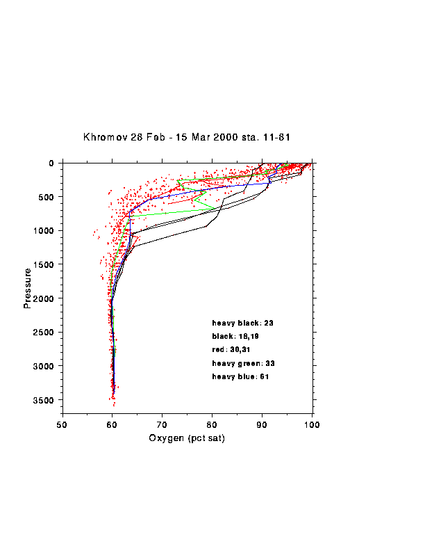
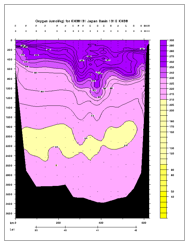
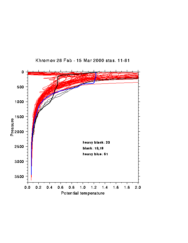
(1) Intermediate depth open ocean convection was evident in oxygen, temperature and salinity profiles at four stations south of Vladivostok, near 41N, 132E (stations 18, 19 and 23). Station 23 (41 0'N, 132 20'E) showed the deepest penetration of oxygen saturation greater than 80% (Figure 5), suggesting that convection had reached to about 1040 dbar. A vertical section of oxygen along 131E, with a deviation through station 23, also shows the depth of this high oxygen layer (Figure 6). Despite the location of several stations in the region that was being sampled by the profiling floats 230 and 262, only this station showed penetration of high oxygen to greater than 800 m. The temperature and salinity structure at station 23 includes two separate layers that could have been well-mixed. Oxygen saturation at station 23 (and also adjoining stations 20 and 21) is quite low at the sea surface, at about 90%, and then relatively homogeneous below dropping to 80% only below 1100 m. The low surface saturations could be a signature of vigorous vertical mixing. The only other station in the survey with low surface oxygen was station 34, in the open sea south of Vladivostok.
The history of the profiling floats, the relatively low surface oxygen saturation, the depth of penetration of surface oxygen values, and the relative homogeneity of properties in two thick layers at station 23 suggest that convection occurred to about 1100 m depth in February in this region. The disappearance of coldest SST in this region at the end of February, and the lack of observation of truly homogeneous temperature/salinity, suggests that collapse of the homogeneous layer in the absence of continued forcing was very rapid, on the order of less than one or two weeks.
The implied maximum density of surface convection at station 23 is 27.329 sigma theta, 32.034 sigma 1, although the data are not yet well calibrated.
(2) In the northern Japan Sea, just east of the Liman Current and winter ice edge, a well-mixed surface layer of 360 m thickness was found (station 61 at 42 58'N, 135 39'E - Figure 7 ), with oxygen saturation greater than 90% ( Figure 5 ). This station was near the location of profiling floats that showed relatively uniform surface layers of about this depth in February. No other stations had mixed layers (in temperature) this deep although many stations in the region showed 200 m thick mixed layers.
Based on oxygen saturation, there is an axis of winter mixed layers of 250 to perhaps 400 meters thick just offshore of the 3000 meter isobath. Station 61 fits within this group, as does station 34 and 33, both of which showed relatively deep high oxygen layers. These depths differ considerably from the apparent deep overturn to 1100 m described in (1).
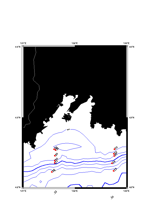
(3) High oxygen saturation is found on the bottom at two stations (30 and 31 - Figure 5) on the continental slope just south of Peter the Great Bay ( Figure 1b). The station depths were 600 and 1400 meters. The high oxygen subsurface layers were about 200-300 meters thick. These layers likely originate from the shelf based on similar observations in April, 1999. The oxygen layer at the deeper station is not highly saturated and in fact fits well with the curve of higher saturations from the intermediate convection stations. This leaves open the possibility that this ventilated water originates from offshore convection and that the vertical profile is a composite of older and newly-ventilated waters, with the newest water found at the bottom.