HYDROGRAPHIC OBSERVATIONS IN THE JAPAN/EAST SEA IN WINTER, 2000, WITH SOME RESULTS FROM SUMMER, 1999
L. D. Talley*, V. Lobanov+, P. Tishchenko, V. Ponamarev+, A. Sherbinin&, V. Luchin&
*Scripps Institution of Oceanography, La Jolla, CA 920930-0230, USA; 1-858-534-9820; ltalley@ucsd.edu
+Pacific Oceanological Institute, Vladivostok, Russia
&Far Eastern Regional Hydrometeorological Research Institute, Vladivostok, Russia
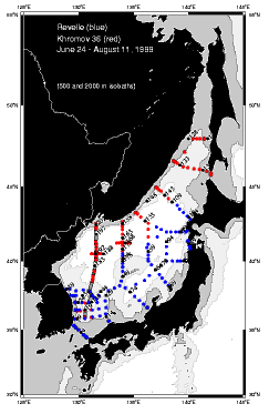
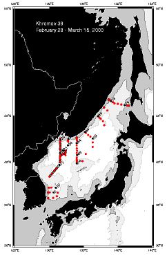
Figure 1. (a) Summer hydrographic cruises of the R/V Revelle (24 June - 17 July, 1999) and Professor Khromov (22 July - 11 August, 1999). (b) Winter, 2000 survey from the Professor Khromov (28 February - 15 March, 2000). Stations used in Figs. 7 and 6 are shown by the gray lines in (a) and (b), respectively.
Summer, 1999 and winter, 2000 hydrographic surveys of the Japan/East Sea (JES) were carried out on the R/V Revelle and Professor Khromov (Fig. 1). The summer cruises (203 stations) covered most of the region, while the winter survey (81 stations) was intended to sample regions of water mass transformation.
The principal scientific goals of the cruises were to provide the highest accuracy physical and chemical data to elucidate the vertical structure of the circulation, budgets for mass (including deep upwelling, overall heat and freshwater budgets), ventilation and mixing sites, the structure of the subpolar front and some aspects of the eddy field and their relation to topography. The winter cruise was undertaken to observe conditions at the end of winter, including documenting convection sites and outflow from ice-covered regions, and the properties of the newly-ventilated waters.
The main winter finding was ventilation penetrating well below the summer pycnocline at three sites: (1) south of Vladivostok, east of a warm eddy, north of the subpolar front (convection), (2) the southern portion of Tatar Strait east of the ice edge (convection), and (3) on the continental slope off Peter the Great Bay (brine rejection). Many results from the summer, 1999 cruises were described in a previous talk (PICES, Vladivostok, 1999) and are not described here.
Background. Historical hydrographic data suggest that ventilation reaching the bottom (> 3500 m) has not occurred since at least the 1930s (Gamo et al., 1986; Kim et al., 1998). Our oxygen data, collected in summer 1999, show that the trend of decreasing oxygen in the deep waters has continued unabated (Figure 2) with no deep oxygen in
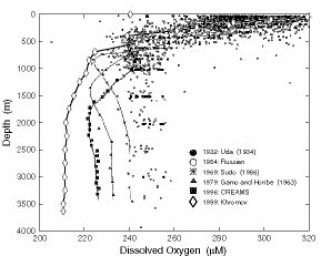
Figure 2. Vertical oxygen profiles from the central Japan Basin. From Kim et al. (1998) with the addition of a summer, 1999, profile (diamonds - station 153 at 42° 45'N, 136° 03'E).
excess of 215 umol/kg, in contrast with 225 in 1996, 232 in 1979 and 240 in 1969 (Kim et al., 1998). The drop in oxygen is greater than the lateral range of deep oxygen, which for our Japan Basin survey was 204 umol/kg (sta. 25) to 215 umol/kg (sta. 153).
There is however ample tracer evidence of ventilation to intermediate depth (Sudo, 1986; Seung and Yoon, 1995; Senjyu and Sudo, 1994), with the primary location between 40°N and Peter the Great Bay. A local maximum in winter surface heat loss is found here due to the strong northerly continental winds from the Siberian High in winter (Kawamura and Wu, 1998). Ryabov (1994) concluded that ventilation also occurs in the Korean Plateau region, based on historical oxygen data. (We found no evidence of this water but our survey did not completely cover this region.)
Sea ice is found from November to March in Tatar Strait, and later in winter in a narrow coastal band along the Primorye coast and in Peter the Great Bay. Brine rejection during sea ice formation can create dense water. Such ventilation has been reported by, among others, Nitani (1972) and Ponamarev et al. (1996).
Conditions prior to the winter, 2000, cruise. Sea surface temperature, water column observations and sea ice maps were available prior to the cruise. AVHRR SST images in February, 2000, showed an extensive region of cold water south of Vladivostok, penetrating southwards to the subpolar front and just east of a large warm, anticyclonic eddy at the western end of the subpolar front. Climatological wind stress curl for winter shows cyclonic forcing east of the eddy location and anticyclonic forcing at the eddy location, due to the northerly winds during cold air outbreaks. The eddy may arise as an overshoot of northward flow from the subtropical region, guided by topography, and limited to the east by the southward flow of the winter cyclonic gyre. The anticyclonic wind forcing may also be a factor. SST images showed cold water east of the eddy until late February. The Khromov reached the area on March 4, just after a slight warming evident in slightly higher SST throughout the region.
Similarly cold or colder surface water was found throughout the subpolar region, so the possible region of ventilation could not be determined from SST alone. The second tool used for steering winter observations was profiling float data (S. Riser) available from a website in real time (http://flux.ocean.washington.edu/japan-sea/index.html). The floats profile from 800 m depth to the surface every seven days. Two floats showed relatively homogeneous layers to 800 m, with relative homogeneity starting as they turned southward at Vladivostok in mid-January (floats 230/262 on January 19/20). In late February, the floats with homogeneous profiles were located at 40.6 to 41.0°N, 132.5 to 132.6°E, in the cold SST region east of the warm eddy. Using these profiles and SST, station locations were selected to sample the well-mixed region and the warm eddy.
Mixed layers in excess of 350 m depth were also apparent prior to the cruise from profiling floats in Tatar Strait east of the ice edge. These observations were also used to adjust our station coverage.
Sea ice was tracked from weekly analyses available from the National Ice Center website (http://www.natice.noaa.gov/pub/West_Arctic/Sea_of_Japan). Sea ice was at its maximum extent during the last week in February. It retreated quickly during the cruise period, which covered the first two weeks of March, and was gone by March 20.
Preliminary winter, 2000, cruise results. The Khromov stations were occupied during the week after the coldest period of winter, based on available AVHRR SST and meteorological conditions (not shown). One additional cold air outbreak occurred when the Khromov was working on the slope just south of Peter the Great Bay, with winds in excess of 22 m/sec. Evidence of convection, based on temperature and oxygen, was found at the winter stations 23 (in the cold pool east of the warm eddy) and 61 (southern Tatar Strait). Evidence of dense slope water, presumably originating from brine rejection in Peter the Great Bay, was found at stations 30 and 31, on the 131°30'E section. The following figures should be viewed in that context, with the evidence of ventilation presented later.
Surface properties. Water colder than 0°C was found at the sea surface all along the Russian coast (Figure 3a). Water colder than 1°C was found in a wide region west of 135° 30'N and east of the warm eddy, which was located around 41°N, 131° 30'E, with a surface temperature above 4°C. A streamer of warm water from the eddy extended eastward, stratifying the top of the convection stations. Salinity was low in the band of cold coastal water, largely coinciding with the ice edge of late February (Figure 3b). The quick retreat of ice in the first week of March suggests that the low salinity water originated from recent ice melt. A band of highest salinity, greater than 34.05, was found offshore and occupied most of the region, including the 132°E convection region. Highest salinity (34.09) was found on the 136°E section, decreasing westward and northward. Calculations of the effect of evaporation on the salinity have not been performed but the decrease of salinity westward and increase of latent heat flux westward (Kawamura and Wu, 1998) suggest that the high salinity influence is largely originates from the Tsushima Warm Current rather than local evaporation.
Surface density (Figure 3c) was maximum in the cold water area south of and well offshore from Vladivostok. It was also high in the Tatar Strait region, again offshore of the low salinity coastal waters and ice edge. The high salinity tongue in the central Japan Basin is also relatively warm and hence a slight density minimum. Overall however, the entire region was of remarkably high density - all greater than 27.3 and many points greater than 27.31. Lowest density occurred in the warm anticyclonic eddy, which also had a very low salinity surface layer, and south of the subpolar front.
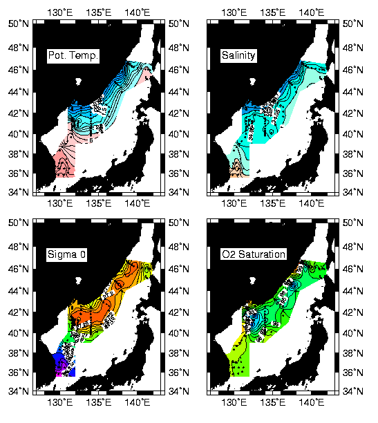
Figure 3. (a) Temperature, (b) salinity, (c) density and (d) oxygen saturation at the sea surface from the March, 2000 survey.
Low surface oxygen saturation values are a sign of recent convection, as mixing brings up oxygen-depleted waters from below the pycnocline. Surface saturations are shown in Figure 3d. Lowest values occur at the locations where convection likely occurred, based on subsurface properties — that is all along the axis of the subpolar gyre, offshore of the Primorye Current, with lowest values at the stations identified through vertical profiles as those with the deepest and most recent convection.
The maximum surface density of 27.31kgm-3 occurred at about 0.06°C (Figure 4a), which was largely the water in the cold area between Vladivostok and 40°N. The entire summer data set is plotted with the winter surface data. All surface data and warm subsurface data fall along nearly the same curve, with density dominated by temperature for temperatures greater than 0.06°C. For lower temperatures, surface density is dominated by salinity and the subsurface waters fall along the very limited tail extending to cold temperatures and higher densities from the maximum sea surface density. Salinity (Figure 4b) is high in the southern JES (Ulleung Basin points, and also throughout the Tsushima Current, and reaches a plateau around 34.05 in the Japan Basin. The buoyancy fluxes that control this decrease and limiting value should be considered.
Convection in the central Japan Basin. Potential temperature as a function of pressure for all CTD stations (Figure 5a) shows evidence of penetrative convection at two stations, with a relatively homogeneous layer extending below the cluster of the remaining stations. In the region identified just before the cruise as being most likely to be convecting, one station (23) had relatively well-mixed potential temperature. The surface had clearly restratified - based on the surface temperature distribution (Figure 3a), restratification was likely due to a streamer of warm water from the nearby eddy. A well-mixed layer to 500 m lay below the surface, underlain by a relatively well-mixed
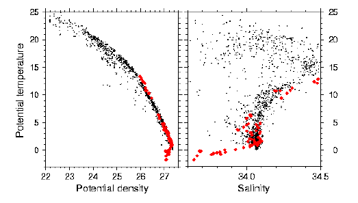
Figure 4. (a) Potential density vs. potential temperature at the sea surface in late winter, 2000 (large diamonds) and for all bottle data points for summer, 1999 (small dots). (b) Salinity vs. potential temperature for the same data sets.
layer extending to about 1100 m. Thus the warmest water at depth occurred at this station, suggesting penetrative convection. Oxygen at the same station, based on bottle data, also suggests that this is recently convected water, with relatively high oxygen extending to 1100 m (Figure 5b). The two layer structure beneath the stratified surface layer is also apparent in oxygen. Clearly we did not sample convection as it occurred. The Khromov observations were made at least one week after cessation of vigorous forcing, and time did not allow a complete sampling of the region. The horizontal scale of convection plumes is on the order of 1 km. Breakdown of convective patches by baroclinic and centrifugal instability occurs rapidly. Therefore it was fortunate to have seen at least this evidence of recent convection, even though the water column was beginning to restratify. It is unclear whether the two layer structure is a result of restratification or is the actual structure of the three-dimensional convective patch, perhaps with convection on a slant rather than exactly vertical.
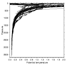

Figure 5. (a) Potential temperature and (b) oxygen from March, 2000. Stations 23 and 61 - heavy solid; stations 18 and 19 -heavy dashed; stations 30, 31 and 33 - heavy dot dash (oxygen only).
Two stations (18 and 19) near the convecting feature at station 23 also show deep penetration of high temperature and oxygen. These stations are within the warm eddy. A vertical section of potential temperature (Figure 6a) including both the warm eddy and the convection station shows that no convection could have occurred within the eddy as it was very strongly stratified. The high temperature at depth was a result of the deepening of isopycnals in the center of this vigorous feature, whose geostrophic velocities relative to the bottom, as calculated from this CTD data, were in excess of 25 cm/sec. The oxygen section (Figure 6b) also shows the penetration of high oxygen to depth as a result of this eddy. In summer, 1999, the section at the same location (131°E) also included a major anticyclonic eddy (likely not the same eddy that was seen in winter, 2000 however), with penetration of high oxygen to depth in the eddy.
Assigning a depth of convection for station 23 at 1040m (break in potential temperature profile), the density of convection is estimated at 27.324 (27.32-27.344). The averages for the upper mixed layer are 0.54°C, 34.057, 27.315 (averaged from 170 to 450 dbar); this layer is quite well mixed. The average potential temperature, salinity and potential density of the deeper relatively mixed layer are 0.47°C, 34.063, 27.324 (averaged from 500-1040 dbar); this layer had begun to restratify.
Tatar Strait convection. A second convective feature was found at station 61 in the southern part of Tatar Strait, with a well-mixed layer depth of 360 m (Figure 5). The density of this convective feature was 27.285, and other average values of 1.22°C, 34.073 psu. While this station contained the only well-mixed layer observed in this region, we hypothesize that such convection occurred at many locations in Tatar Strait during the winter, based on the oxygen distribution, which shows relatively high oxygen to about 400 m throughout the region. Further analysis will include mapping the penetration of high oxygen throughout the winter survey.
Peter the Great Bay brine rejection. In April, 1999, a cruise of the Gordienko sampled post-winter conditions in the same region as the convective feature, and also included detailed observations on the continental slope off Peter the Great Bay. Blobs with elevated oxygen were found to great depth along the slope. In the winter, 2000, survey, two stations show elevated oxygen along the continental slope - stations 30 (600 m and 27.332 sigma theta) and 31 (1103 meters and 27.343 sigma theta) (Figure 5b). The oxygen signals are high relative to values within the same profile, but not high relative to the overall envelope of oxygens. The higher oxygen layer on the deeper of the two slope stations was centered at 1100. The potential density at the oxygen maximum was 27.331. This particular feature therefore ventilated the same depths and densities as the convection farther south at station 23. Detailed surveys of Peter the Great Bay in winter (Yurasov et al., 2000), as well as the April, 1999 cruise show that high salinity waters are found in pockets in the bathymetry. Salinities and densities are much greater than in the interior of the Japan Sea, as a result of brine rejection during ice formation; vigorous mixing of the dense water as they slide off the shelf and into the interior likely greatly reduces its density and contrast with the interior waters. This shelf water is thus a very likely source of continuing ventilation for the intermediate waters. How important it is for deeper waters remains to be determined.
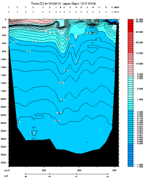
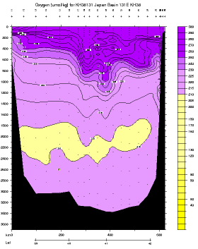
Figure 6. (a) Potential temperature along 131°E, winter, 2000, including stations from the small convection sampling region (see Figure 1b for locations). (b) Oxygen (umol/kg) along 131°E.
Korean plateau ventilation. In a study of historical winter data, Ryabov (1994) suggested that two modes of ventilated waters occur in the JES. One of these, with higher oxygen and higher density than the other, is located on the Korean Plateau (Korea Bay) in the western JES. The westernmost stations of the main winter, 2000, survey were located in this region. However, no properties like those shown by Ryabov were found at these stations. This however does not eliminate the possibility of ventilation in this area in winter, 2000, as it was not possible to sample farther west.
Discussion. The convective station south of Vladivostok ventilates the salinity maximum layer of the JES (known as Upper Japan Sea Proper Water). High oxygen was found in this region, in the anticyclonic eddy, in summer, 1999 as well (Figure 7). The winter observations show that convection did not occur in the eddy itself, but nearby, with ventilated properties swept into and around the eddy. High oxygen was found along the axis of the subpolar gyre in the Japan Basin in the summer, 1999, survey, The recently-ventilated station in Tatar Strait also affected the salinity maximum layer. We believe that processes other than convection create the salinity maximum layer, beginning in the Tsushima Current area off Hokkaido (see Tishchenko et al., 2000), based on the summer, 1999 survey. Winter convection may be one of the factors that sets the salinity of the maximum in the Japan Basin however, as the convection penetrates into the salinity maximum and mixes it with overlying fresher water of coastal and possibly precipitation origin. Following winter, the surface layer would restratify both in temperature and salinity. The higher salinity of this region accompanied by heat loss during westward advection, and finally massive heat loss in the cold air outbreak region south of Vladivostok (e.g. Kawamura and Wu, 1998) create the conditions for the deepest
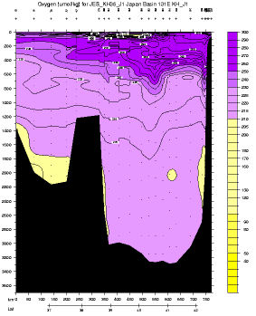
Figure 7. Oxygen along 131°E from summer, 1999. Station locations are shown in Figure. 1a.
convection at this farthest corner of the subpolar gyre, just north of the subpolar front and east of the warm eddy that defines its western edge.
Brine rejection in Peter the Great Bay is apparently also a factor in ventilating the mid-depths of the Japan Basin. Higher oxygen was found in summer, 1999, along the northern boundary (Figure 7) to a density of 27.325, and most likely results from this ventilation source. The maximum density that can be ventilated from this source depends on entrainment as the plumes of dense water slide down the slope, and could be best estimated by use of a model such as Price and Baringer's (1994).
References
Gamo, T., Y. Nozaki, H. Sakai, T. Nakai and H. Tsubota, 1986: Spatial and temporal variations of water characteristics in the Japan Sea bottom layer. J. Mar. Res., 44, 781-793.
Kawamura, H. and P. Wu, 1998: Formation mechanism of Japan Sea Proper Water in the flux center off Vladivostok, J. Geophys. Res., 103, 21611-21622.
Kim, K.-R., K. Kim, D.-J. Kang, S. Y. Park, M.-K. Park, Y.-G. Kim, H.S. Min, and D. Min, 19948: The East Sea (Japan Sea) in change: a story o dissolved oxygen. MTS Journal, 33, 15-22.
Minami, H., Y. Kano and K. Ogawa, 1998: Long-term variations of potential temperature and dissolved oxygen of the Japan Sea Proper Water. J. Oceanogr., 55, 197-205.
Nitani, H., 1972: On the deep and bottom waters in the Japan Sea. In: Researches in hydrography and oceanography, ed. D. Shoji, Tokyo, 1451-201.
Ponamarev, V. I., A. B. Salyuk, and A. S. Bychkov, 1996: The Japan Sea Water variability and ventilation processes. Fourth CREAMS Workshop, Vladivostok, Russia, Feb. 12-13, 1996, 63-69.
Price, J. F. and M. O. Baringer, 1994: Outflows and deep water production by marginal seas. Progr. In Oceanogr., 33, 161-200.
Ryabov, O., 1994: On a bottom water origin of the Japan Sea. CREAMS '94 Workshop, Fukuoka, 91-94.
Seung, Y.-H. and J.-H. Yoon, 1995: Some features of winter convection in the Japan Sea., J. Oceanogr., 51, 61-73.
Senjyu, T. and H. Sudo, 1994: The upper portion of the Japan Sea proper water: its source and circulation as deduced from isopycnal analysis. J. of Oceanogr., 50, 663-690.
Sudo, H., 1986: A note on the Japan Sea Proper Water. Prog. Oceanogr, 17, 313-336.
Tishchenko, P. Ya., L. Talley, I. A. Zhabin, V. I. Ponamarev, A. Nedashkovsky, S. Sagalaev, E. Il'ina, V. Luchin, and V. B. Lobanov, 2000: Hydrochemical structure of the Japan/East Sea in summer, 1999. CREAMS-2000, Vladivostok, abstracts.
Yurasov, G.I., N. S. Vanin, Yu. I. Zuenko, S. S. Ermolenko, and A. P. Nedashkovskiy, 2000: Monitoring of update state of Peter the Great Bay waters on a base of observations during November 1999-April 2000. CREAMS-2000, Vladivostok, abstracts.