1. Introduction
2. Surface waves, tides and tsunamis in the tropical Pacific
3. Temperature and salinity distribution in the tropical Pacific
4. Ocean circulation in the tropical Pacific
5. Forcing of the circulation
6. Climate variability in the tropical Pacific
Figures
References
This is a brief introduction to the basic physical
oceanography of the Pacific island region -
the circulation, tsunamis, waves, temperature and salinity
distributions, and the forces that create these.
Since the tropical Pacific contains most of the
island groups, and since the dynamics and properties of
the tropical oceans differ somewhat from those at higher
latitudes, this chapter concerns only
tropical oceanography for compactness.
The tropical Pacific is usually considered to lie
between the astronomically-defined tropics - the Tropic of
Cancer (23°N) and the Tropic of Capricorn (23°S).
There are other useful definitions of the tropics, based on
how far the effect of the equator extends to the north and south
in the atmosphere - approximately 20°.
Within the ocean itself, the currents within 15 to 20°
of the equator are oriented much more east-west than the currents
at higher latitudes.
The tropics are a region
of excess heating from the sun and towering cloud convection
and rainfall in narrow bands across the Pacific.
The warm surface waters of the tropics sustain
the coral reefs which are a central feature of the islands' ecology.
Compared with areas at higher
latitudes, the frequency of storms and the average strength of the
winds are low. As these affect the average height of surface waves,
the wave climate of the tropics is relatively mild.
Tsunamis (or "tidal waves") are a feature
of life on a number of the Pacific islands which stand in the
path of these fast-moving waves which are created by earthquakes
or volcanoes.
The tropical Pacific is the seat of the global climate
cycle known as "El Nino", which occurs every two to seven
years. When the easterly trade winds
weaken in the tropical Pacific, warm water builds up across the equatorial
Pacific. This further changes the weather patterns in the atmosphere above,
and the changes are propagated enormous distances around the globe
through the atmosphere. The resulting disruption creates
drought in some regions - the western tropical Pacific and
northern Australia - and large rainfall in other regions - the
eastern tropical Pacific and the west coasts of North and South
America.
The wave climate of the Pacific Islands region is dominated by long period
swell reaching the area from distant storms, by relatively low
amplitude, short period waves generated by more local winds, and the
occasional bursts of energy associated with intense local storms.
Waves are characterized by their wavelength (distance between
crests or troughs), their period (time between successive
passage of a crest past a fixed point), and their height or amplitude.
Each type of wave can also be characterized by its restoring force.
For surface waves, the restoring force to perturbations
in sea surface height is gravity, and so the waves are sometimes
referred to as surface gravity waves.
Surface waves are mostly created by wind blowing across the sea surface.
(The exceptions are the tides and tsunamis which are described in
the following sections.)
The first waves to appear in response to wind
are very small "capillary" waves, with
wavelengths on the order of centimeters. These are apparent
in a lake when a gust of wind blows past. If the wind persists,
longer and longer waves are generated. The wave heights build,
proportionally to the strength of the wind and how long it blows.
Local waves forced by the wind travel in the direction of the wind.
The period of a wave is the time between the passing of
successive crests. For wind-generated waves, periods are
on the order of seconds to many minutes for the shortest to the
longest waves, respectively.
A large storm generates numerous surface waves moving in all
different directions under the storm. These travel away from
the storm location, so if the storm is localized, waves will
radiate outwards from the storm area. The longer the waves,
the faster they travel. Short waves are damped out much more
rapidly by friction than are long waves.
Long waves generated by storms at high latitudes, such
as in the Gulf of Alaska, or far south in the Antarctic,
or generated by earthquakes
can travel clear across the Pacific without much attenuation.
Typically the sea state (field of waves) is a jumble of waves of
many different wavelengths, moving in many directions since the
wind forcing can be in many different directions.
In the tropical Pacific, the wave field can be thought of as a
superposition of waves forced by the local trade winds - the
"tradewind sea" - and waves forced by distant storms.
The tradewind sea is of small amplitude, and choppy since it is
produced locally by winds which shift. The long
period swell from far away storms is also of relatively low
amplitude in the open ocean, and much more unidirectional than
the tradewind sea.
The height of waves is now measured by various satellite
sensors.
A measure commonly used is "significant wave height",
which is the average height of the highest one-third of the
waves, where the height is measured from trough to crest.
NASA routinely produces
maps of significant wave height
from satellite altimetry information (Fig. 1). The altimeter
measures the height of the sea surface, although the significant wave
height is actually constructed from the properties of the radar pulse.
Maps and information are available online, both for previous years
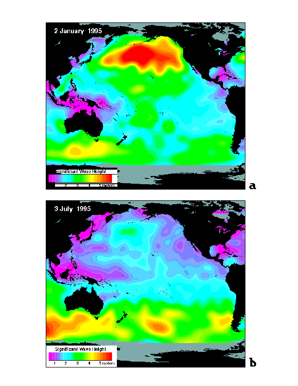
and also in near real-time. Monthly analyses for the globe show
that the average wave height in the tropical Pacific is typically less than 3
meters, regardless of season, whereas wave height at high latitudes
in the winter hemisphere
typically reaches 3 to 6 meters due to large storms (Fig. 1).
The water particles in a surface wave move in ellipses - up and forward
in the direction of the wave propagation as the wave crest passes,
and down and backwards as the trough passes.
In deep water, waves with the longest wavelengths (distance from
crest to crest) travel faster than short waves.
When the wavelength becomes of the same size as the ocean bottom depth,
the waves feel the bottom.
The particle trajectories become more elliptical and the amplitude
grows. The traveling speed of all waves becomes the same and
proportional to the square root of the water depth - thus the
waves travel more slowly and all together in shallower water.
As waves reach the shallow waters of a reef and island, they shoal,
increase in amplitude and eventually break. The short period,
tradewind sea produces relatively small surf height because
of the short wavelengths. Large surf is produced by the long
period swell from distant storms because of the correspondingly
longer wavelength. The north shores of the Pacific islands receive
this long-period swell in the northern hemisphere winter, and the
south shores in the southern hemisphere winter. Wave heights of
6 meters in the surf zone are not uncommon. Winter swell
on the north shore of Oahu occasionally reaches over 15 m (Flament
et al., 1997).
Because the Pacific islands are small and rise steeply from the
sea floor, there is little shelf area which can affect the progress
of the long waves. (Continental shelves typically refract waves.)
Thus the waves impinge directly on the shore or reef and do not wrap around
the islands.
Breaking waves contain a lot of energy, some of which goes into
production of local currents - first into longshore currents and
then into rip currents which carry water back out to sea.
Most of the circulation in the surf zone, and in lagoons inside
reefs, is produced by breaking waves.
The complete tide is a composite of the moon (lunar) and sun (solar) tides.
Considering just the moon,
the gravitational between the earth and moon
creates bulges of water on opposite sides of the
earth. The water bulge nearest the moon/sun is due to domination of
gravitational attraction over centrifugal force; the water bulge
opposite the moon/sun is due to domination of centrifugal
force. The two forces cancel at the earth's center.
Since the earth also rotates daily,
a point on the earth passes through these bulges twice a day,
resulting in semi-diurnal (twice daily) components to the tide at
each location. Because the
moon and the sun do not generally lie over the equator, one of the bulges
at a given point on the earth is
larger than the other, leading to what is known as the "diurnal
inequality", which lends a diurnal (daily) component to the tide.
A modulation of the tidal range results from the relative position of the
moon and the sun: when the moon is new or full, the moon and the sun act
together to produce larger "spring" tides; when the moon is in its first or
last quarter, smaller "neap" tides occur. The cycle of spring to neap tides
and back is half the 27-day period of the moon's revolution around the
earth, and is known as the fortnightly cycle. The combination of diurnal,
semi-diurnal and fortnightly cycles dominates variations in sea level
throughout the islands.
The geometry of the oceans - the basin shape,
local coastline, bays, and even harbor geometry -
has a major effect on the local behavior of the tides.
On scales of oceanic basins, tides exist as very long waves propagating in
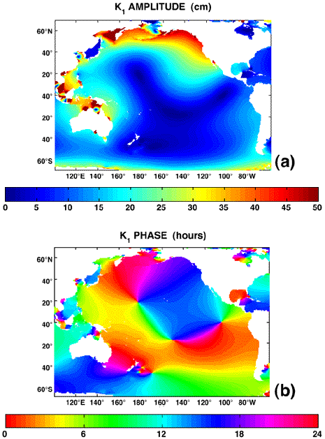
patterns determined by their period and the geometry of the basin. Figure 2
shows the response of the Pacific to the tidal period of 23 h 56 min,
the largest diurnal (once daily) component.
The tidal amplitude (Fig. 2a) is very low in the central Pacific, but
is higher in the tropical region of Australia, New Guinea and Indonesia,
as well as far to the north in the Gulf of Alaska and subpolar region.
Lines along which high tide occurs at the
same time (called phase lines - contours of constant
color in Fig. 2b), converge to several points
where the tidal range is zero. There are four of these points, called
"amphidromes" in the Pacific: one on the North Pacific near the dateline,
one near the equator in the eastern North Pacific,
ond in the central South Pacific near Tahiti,
and one east of New Zealand. Phase lines rotate
counter-clockwise around the amphidromes in the North Pacific and clockwise
around the ones in the South Pacific.
For example, at the Hawaiian Islands, the offshore diurnal tide
reaches the Hawai'i island first, then sweeps across Maui, O'ahu and finally
Kauai.
Local bathymetry affects the ranges and phases of the tides along the shore,
as the tidal waves wrap around the islands. For example, high tide at
Haleiwa on the north shore of O'ahu occurs over an hour before high tide at
Honolulu Harbor.
Even though the tides at one point on a coastline are not in phase
with those at even a nearby point,
the tides at that point can be completely predicted if they
are measured for several months, because the
forcing which creates the tides is so extremely regular.
Tidal currents result from tidal variations of sea level, and
near the shore are often stronger than the large scale circulation.
Complete mapping of tidal currents requires direct measurements.
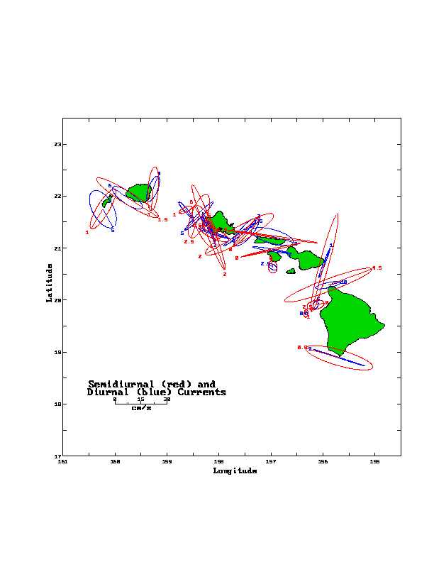
As an example, the semidiurnal and diurnal tidal currents for Hawaii (Fig. 3
from Flament et al., 1997), show that the semi-diurnal and
diurnal tidal currents tend to be aligned with the shoreline. Due to high
variability of tidal currents around the islands, however, this statistical
picture may not correspond to the flow at a particular time: tidal currents
cannot be predicted as precisely as sea level. Strong swirls often result
from tidal currents flowing around points and headlands, and present hazards
to divers.
When the seafloor is raised suddenly during a shallow earthquake, water is
raised with it, producing a mound of excess water at the sea surface.
Gravity collapses the mound, producing a series of waves: a tsunami.
Tsunamis are gravity waves, just like those generated by the wind, but
their period is much longer, on the order of 10 to 60 minutes. While
earthquakes are the most common cause of tsunamis, the waves are generated
by any phenomenon which rapidly changes the shape of the sea surface over a
large area: volcanic eruption, landslide, even meteorite impact. Since the
largest shallow earthquakes occur in the subduction zones which ring the
Pacific, and since these same subduction zones are dotted with volcanoes,
the tsunami hazard throughout the tropical Pacific is high.
On the open ocean, the wavelength of a tsunami may be as much as two
hundred kilometers, many times greater than the ocean depth which is
on the order of several kilometers. This huge
wavelength means that the entire water column, from surface to bottom, is
set into motion. Tsunamis therefore always behave like waves in shallow
water, which means, as already discussed above, their speed is
proportional to the square root of the water depth. For typical ocean
depths of 5 km, a tsunami will advance at 800 km/hr, about the speed of jet
aircraft. A tsunami can therefore travel from one side of the Pacific to
the other in less than a day. The speed decreases rapidly as the water
shoals: in 15 m of water the speed of a tsunami (or of any wave with long
enough wavelength to "feel" the ocean bottom) will be only 45 km/hr.
As the tsunami slows in shoaling water its wavelength is shortened. Just as
with ordinary surf, the energy of the waves must be contained in a smaller
volume of water, so the waves grow in height. The maximum height the
tsunami reaches on shore is called the runup. Any runup over a meter is
dangerous. Waves reaching only a meter above sea level may not seem
threatening, but the waves of a tsunami are unlike normal waves. Even
though the wavelength has shortened, a tsunami will typically have a
wavelength in excess of ten kilometers when it comes ashore. Each wave
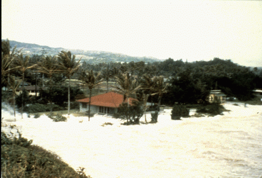
therefore floods the land (Fig. 4) as a rapidly rising tide (hence the
common English term "tidal wave") lasting for several minutes. The
individual waves are typically from ten minutes to a half-hour apart, so
the danger period can last for hours.
Runup can vary dramatically depending on seafloor topography. Small islands
with steep slopes experience little runup; wave heights there are only
slightly greater than on the open ocean. For this reason the smaller
Polynesian islands with steep-sided fringing or barrier reefs are only at
moderate hazard from tsunamis. Such is not the case for the Hawaiian
Islands or the Marquesas, however. Both of these island chains are almost
devoid of barrier reefs and have broad bays exposed to the open ocean. Hilo
Bay at the island of Hawaii and Tahauku Bay at Hiva Oa are especially
vulnerable. During a tsunami from the Eastern Aleutians in 1946, runup
exceeded 8 m at Hilo and 10 m at Tahauku; 59 people were killed in Hilo,
two in Tahauku (Shepard, et al., 1950; Talandier, 1993). Similarly, any gap
in a reef puts the adjacent shoreline at risk. The tsunami from the Suva
earthquake of 1953 did little damage because of Fiji's extensive offshore
reefs. Two villages on Viti Levu located opposite gaps in the reef,
however, were extensively damaged and five people were drowned (Singh,
1991).
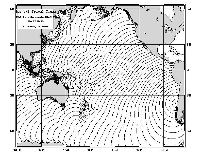
Tsunamis are generated by shallow earthquakes all around the Pacific, but
those from earthquakes in the tropical Pacific tend to be modest in size.
While such tsunamis may be devastating locally, they decay rapidly with
distance and are usually not observed more than a few hundred kilometers
from their sources. That is not the case with tsunamis generated by great
earthquakes in the North Pacific or along the Pacific coast of South
America. About half-a-dozen times a century a tsunami from one of these
locations sweeps across the entire Pacific, is reflected from distant
shores, and sets the entire ocean oscillating for days. The tsunami from
the magnitude 9.5 Chile earthquake of 1960 (Fig. 5) caused death and
destruction throughout the Pacific: Hawaii, Samoa, and Easter Island all
recorded runups exceeding 4 m; 61 people were killed in Hawaii.
In Japan 200 people died. A similar tsunami in 1868 from northern
Chile caused extensive damage in the Austral Islands, Hawaii, Samoa, and
New Zealand. There were several deaths in the Chatham Islands (Iida, et
al., 1967).
The tsunami from a local earthquake may reach a nearby shore in less than
ten minutes, making warning a difficult task (though in this case the
shaking of the ground provides its own warning). For tsunamis from more
distant sources, however, accurate warnings of when a tsunami might arrive
are possible because tsunamis travel at a known speed (e.g., Fig. 5). The
current international tsunami warning system has 26 member nations which
coordinate their warning activities through the Pacific Tsunami Warning
Center in Hawaii. The Hawaii center uses seismic data from the global
seismic network to identify and characterize potential tsunamigenic
earthquakes, then verifies if a tsunami has been generated by querying tide
gauge stations near the source. While the system is far from perfect (about
half of the warnings are false alarms), performance is constantly improving
and there have been no missed warnings.
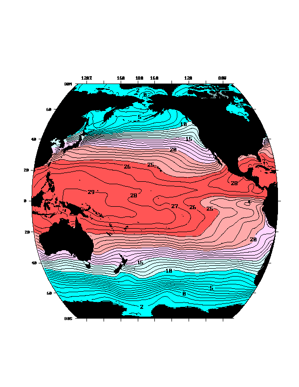
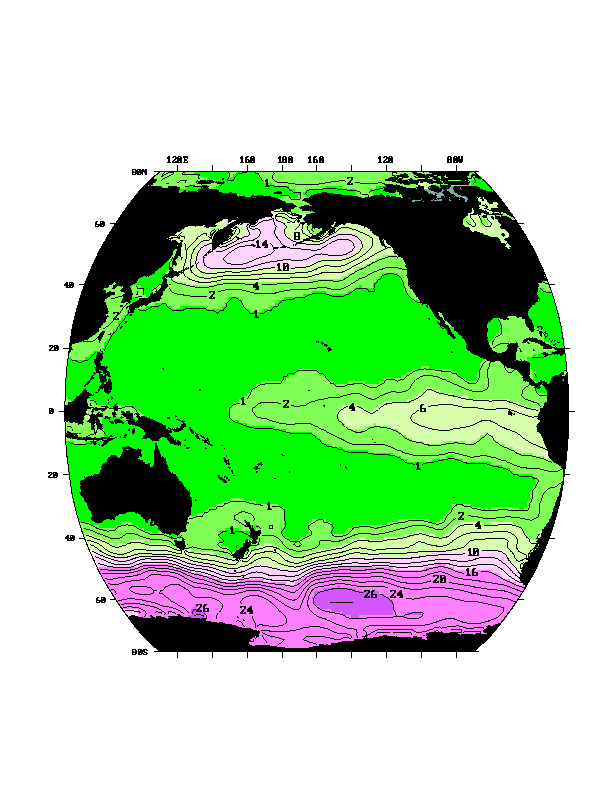
Ocean surface temperature globally is dominated by excess
heating in the tropics compared with higher latitudes,
resulting mainly from higher radiation from the sun in the
tropics. This leads to a sea surface temperature difference
from equator to pole of about 30°C (Fig. 6). In the
tropics, including the tropical Pacific, the maximum sea
surface temperature is around 28°C and can rise to at most
30°C. This is considerably cooler than the maximum
temperatures regularly found over land, of about 50°C. It is
currently hypothesized that the main regulation on the
maximum ocean temperature is through cloud formation.
Cloud formation increases dramatically when the
sea surface temperature is greater than about 27.5°C (Graham and Barnett,
1987). The increased cloudiness increases the albedo (reflectivity
of the earth/atmosphere to space), which
reduces the solar radiation reaching the sea surface
(Ramanathan and Collins, 1993), and thus keeps the surface
temperature from rising much more.
The sea surface
temperature is not uniformly high in the tropical Pacific.
A large "warm pool" is found in the central
and western Pacific (Figs. 6 and 8), and also extends into the eastern
Indian Ocean. Surface water in the eastern equatorial Pacific
is several degrees cooler than in the west.
The vertical thermal structure of the upper ocean is responsible for
these differences. In the western Pacific, the
surface layer, which is fairly well mixed, is approximately 100 meters
thick (Fig. 8), and warmer than about 28°C.
Just below this surface layer, the temperature changes
rapidly downward (for instance at 100-150 meters depth in the west in Fig. 8);
this is called the "thermocline".
In the central and eastern Pacific, the surface
layer is shallower, and so colder water and the thermocline
are found closer to the surface.
Upwelling in the eastern Pacific draws this cooler water to
the surface, creating the equatorial "cold
tongue" at the sea surface (Fig. 6).
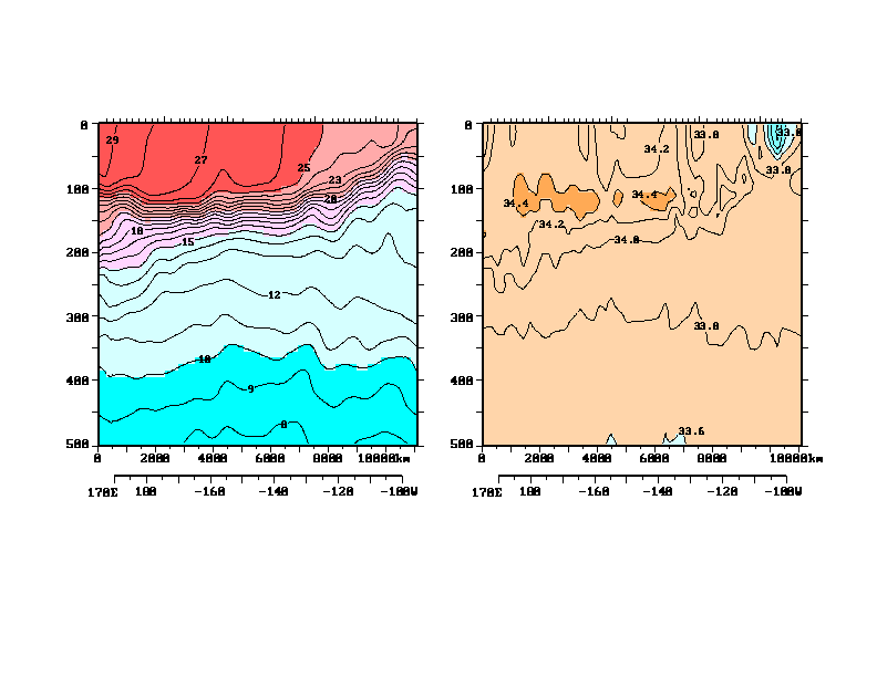
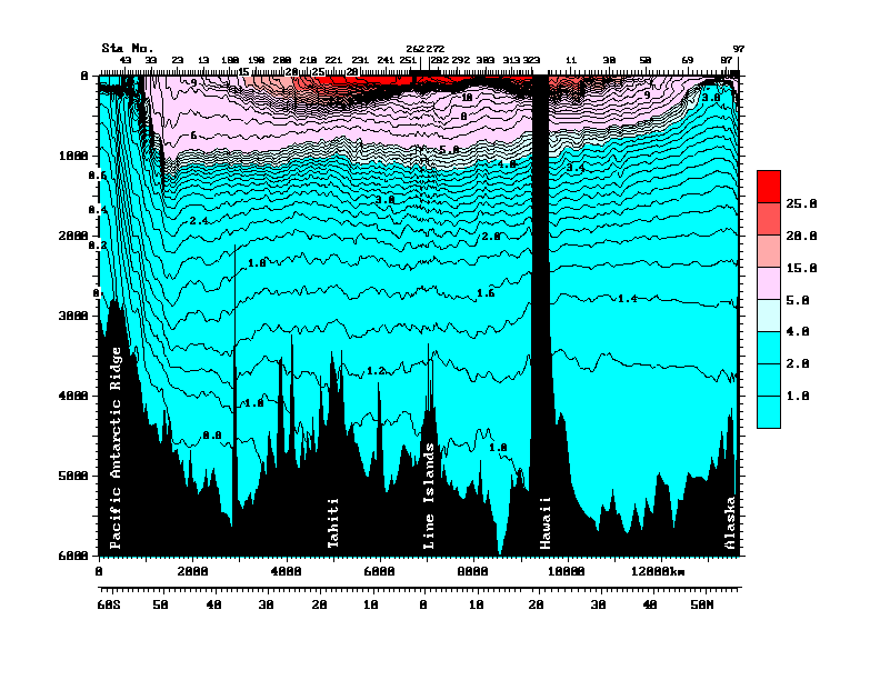
Upwelling of cold water at the equator is apparent in sections
crossing the equator (Fig. 9b from Wyrtki and Kilonsky, 1984).
Upwelling in the western Pacific is somewhat
weaker than in the east and draws up only warm water, and so an
equivalent cold tongue along the equator is absent.
Upwelling is common along the west coast
of South America, off Ecuador and Peru, and along the west
coast of Central and North America. As a result of both the upwelling
and the eastern boundary currents which flow towards the
equator in these regions, sea surface temperatures are relatively
low along these coasts. The winds which create upwelling are
strongest in the area just west of
Costa Rica. Here the thermocline is lifted to
within 10 meters of the sea surface, and is called
the Costa Rican Dome (Hofmann et al., 1981).
Below the sea surface, temperature decreases to the
ocean bottom (Figs. 8, 9 and 10).
The most rapid change is in the upper 500 meters, in the
thermocline.
Changes are more gradual below this. Temperature
reaches about 1.2°C in the abyssal tropical Pacific.
The initial temperature and salinity of all ocean water is set
at the sea surface. The sea surface temperature
distribution (Fig. 6) shows that water
colder than about 18°C comes from latitudes higher than about
30°, hence outside the tropics. Waters of about 4-6°C
come from latitudes of about 40-45° (northern and
southern hemisphere). The coldest waters
flow northward from the Antarctic region.
These southern hemisphere waters, which
fill the Pacific below 1000 to 1500 meters, are part of a
circulation which extends through all of the oceans.
The deepest waters come from the
the Weddell and Ross Seas of the Antarctic and
the Greenland Sea just north of the North Atlantic.
The North Pacific does not produce any of this deep water,
and so its deep waters have traveled a long distance
from their sea surface origin.
These deep waters have spent about 500 years making the
journey to the deep North Pacific (and slightly
less time to the deep tropical Pacific).
Waters which have been far from sea surface forcing (heating/cooling
and evaporation/precipitation)
for a long time are fairly uniform because they mix
with each other. Thus the
deep Pacific contains a large amount of water in a very
narrow range of temperature and salinity, centered around
1.2°C and 34.70 in practical salinity units (e.g. Worthington,
1981). (Salinity is defined in the next paragraph.)
This water must upwell slowly and eventually
complete the overturning cycle by reaching the sea surface,
perhaps very far from the deep North Pacific.
Sea water density depends on temperature (warm water is
less dense), and also on the amount of material
dissolved in the water. The latter is mostly what is referred to
as "sea salt", and is a combination of various salts.
The total amount of salt in the world
ocean is constant on all but the longest geological timescales.
However the total amount of fresh
water in the ocean is not constant - it is affected by
evaporation, precipitation and
runoff. Hence salinity, which is more or less the grams of
salts dissolved in a kilogram of seawater, varies as a
result of surface freshwater inputs and exports.
(Precise salinity definitions and measurement
methods are described in introductory physical
oceanography textbooks such as Tomczak and Godfrey, 1994 or Pickard
and Emery, 1990.)
The total range of salinity in most areas of the ocean is
small enough that temperature actually contributes more
to sea water density differences, but salinity differences
are significant and important.
For instance, if saltier water lies above fresher water, then
the temperature difference between the two must be large
enough to ensure stability (light water over dense water).
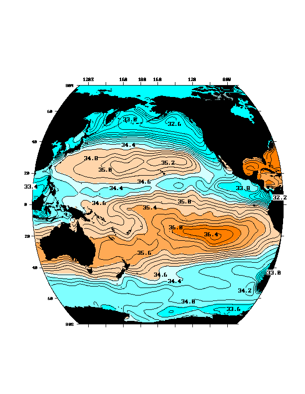
Surface salinity in the Pacific (Fig. 7) shows clearly the net
result of the atmospheric circulation described in the
Climate Chapter. Cloud formation and high precipitation occur
in regions of rising, humid air, which
are associated with low atmospheric pressure at the sea surface,
such as in the Intertropical Convergence Zone (ITCZ) at 5-10°N and
subpolar regions poleward of 40° .
Surface salinity is low where precipitation is high.
Evaporation and hence surface salinity are high
where the air is dry -
regions of atmospheric divergence (high pressure zones at
the surface).
Because temperature dominates the vertical density differences
in the ocean, it decreases downward almost everywhere.
Thus although salinity also contributes to density,
the salinity distribution can be more complex, with
regions of salty water lying over fresher water and
vice versa (Figs. 8b and 11).
Such salinity inversions are common. In cross
section from south to north, the high salinity in the
surface evaporation cells
extends down to the thermocline. The
fresher water associated with the ITCZ
extends fairly deep. Below the high salinity surface water
is found a layer of low salinity "intermediate water" which
extends from the rainy subpolar latitudes in the south and
north towards the equator. Below this, the deep Pacific is
filled with relatively more saline waters originating from
the deep waters around Antarctica and from the Atlantic.
Along the equator surface salinity is lowest in
the western Pacific, where normally there is much
more rainfall than in the central and eastern equatorial
Pacific (Figs. 7 and 8b). The freshest surface water in the western equatorial Pacific
actually extends only partway down into
the vertically-uniform, warm surface layer with salinity increasing
strongly downward midway
within this uniform temperature layer.
Hence the surface stratification is dominated by salinity
rather than temperature (Lukas and Lindstrom, 1991). A relatively
sharp north-south front separates the fresh western equatorial surface
water from the more saline central Pacific surface water. During
periods such as El Nino when the trade winds slacken (section 6 below), the
western fresh, warm water floods eastward towards the central Pacific along
the equator (Roemmich et al., 1994).
Biological productivity in the ocean
relies on nutrients in the sunlit surface layer (euphotic zone - about
100 meters depth).
The principal nutrients which
are routinely measured are nitrate, phosphate and dissolved silica.
They are consumed by plants and animals in the ocean's surface layer.
They are "regenerated" at depth as the decaying
plants and animals and fecal pellets fall through the water column,
with some portion, especially of the silica-bearing hard parts, reaching
the ocean bottom.
Thus nutrients are severely depleted in the surface layer where they
are used almost as quickly as they appear there.
Nutrients are found in abundance below the surface layer,
especially where waters have been separated from the sea surface for
a long time.
Nutrients reach the euphotic zone through upwelling, and so upwelling
regions have slightly higher nutrient content and much higher
biological productivity than downwelling regions.
The most productive regions occur where upwelling is vigorous
and where the nutrient-rich thermocline is near the sea surface.
Near-surface nutrients in the Pacific
are high in the equatorial and eastern
tropical Pacific where upwelling is high, and low in
the subtropical downwelling regions poleward of about 20° (Fig. 12).
Surface nutrients
are higher in the eastern equatorial Pacific than in the western,
reflecting the upwelling of the thermocline waters towards the east
(as seen in the temperature distribution of Fig. 6).
The Pacific sea surface circulation
(Fig. 13) consists of two large "subtropical gyres" centered at
30°N and 30°S, which rotate clockwise in the northern hemisphere
and counterclockwise in the southern hemisphere,
a "subpolar gyre" centered at about
50°N and rotating counterclockwise,
a major eastward flow which circles Antarctica called the "Antarctic
Circumpolar Current",
and complicated but predominantly zonal (east-west) currents
in the tropics between about 15°N and 15°S. At the sea
surface, flow is westward from 30°S up across the equator to
about 5°N. This westward flow is all called the "South
Equatorial Current". Between 5°N and
10°N lies a strong eastward flow, termed the North Equatorial
Countercurrent. It is associated with and driven by the
winds of the ITCZ. The westward flow between 10N and 30N
is called the North Equatorial Current (NEC). The northern half of the
NEC is actually part of the subtropical gyre and the southern
half is part of the ITCZ's elongated counterclockwise flow.
Sometimes a weak ITCZ (South Pacific Convergence Zone) is also present
in the southern hemisphere,
creating an occasional appearance of a South Equatorial
Countercurrent analogous to the North Equatorial
Countercurrent.
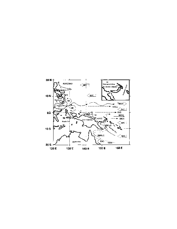
In the western tropical Pacific,
the circulation is dominated
by strong currents which abut the western
boundary (Fig. 14, from Fine et al.,
1994). Western boundary currents are a central feature
of all circulation patterns worldwide.
In the tropical and South Pacific, the western boundary
currents are complicated by the
many islands and deep ridges. Australia forms the largest
single part of the boundary. In the North Pacific, the
westward-flowing North Equatorial Current reaches the
western boundary at Mindanao in the Philippines. It splits
into a northward flow, called the Kuroshio, and a southward
flow, called the Mindanao Current. The Kuroshio flows into
the East China Sea and then northward to the southern end of
Japan (Kyushu) where it splits into a major flow eastward
along the eastern coast of Japan, and a weaker flow, called
the Tsushima Current, into the Japan East Sea. The Kuroshio
is one of the strongest currents in the world, similar to
the Gulf Stream and the Antarctic Circumpolar Current in
strength. It affects climate in Japan through its warmth
and fisheries off Japan through both its warmth and relative
lack of nutrients. The Mindanao Current flows southward
along Mindanao and separates to flow eastward into the North
Equatorial Countercurrent at about 5°N. A portion turns
westward at the southern end of Mindanao and enters the
Celebes Sea.
"Eddies" (circulations of about 50 to 200 km size which are often variable over
a period of weeks to months)
are usually found east of Mindanao and east of
Halmahera. The water entering the Celebes Sea forms the
beginning of flow westward through the complex of
Indonesian islands, threading through to Java and thence
into the Indian Ocean.
In the South Pacific, the very
broad, westward-flowing South Equatorial Current reaches the
western boundary through a complex of islands. The northern
portion forms a northward-flowing western boundary current
along New Guinea, called the New Guinea Coastal Current
(Lindstrom et al., 1987; Tsuchiya et al., 1989). This flows
northward to the equator. A portion of it turns eastward
along the equator and apparently forms part of the
eastward-flowing subsurface Equatorial Undercurrent. A
portion may continue slightly northward, joined by the
westward flow just north of the equator, and then turns
eastward, joining the separated Mindanao Current, into the
North Equatorial Countercurrent.
The remainder of the
westward-flowing South Equatorial Current flows north of
Fiji into the Coral Sea and reaches the western boundary at
Australia. Here it turns southward into the East Australian
Current, which is the western boundary current, and then
flows southward to the northern tip of New Zealand. At this
point, the current meanders a great deal and some portion of
it separates and flows eastward just north of New Zealand as
the North Cape Current. The broad flow between New Zealand
and Fiji is also eastward.
The large-scale surface flow is affected
only by the larger land masses, and not much by the small
islands dotting the tropical and South Pacific.
Intermediate and abyssal flow however are strongly affected
by the ridges in which the small islands are embedded, as
described next.
In most places of the world ocean, the currents vary only gradually
from surface to bottom - they are usually strongest
at the surface where they are closest to the wind forcing, and gradually
blend into the circulation of the abyss.
However, within 2 or 3° latitude of the equator, the subsurface
currents are much more complicated (Fig. 9a from Wyrtki
and Kilonsky, 1984). Between 100 and 200 meters depth lies
the strong eastward-flowing Equatorial Undercurrent. The undercurrent
was originally discovered by Townsend Cromwell during a
research expedition in the 1950's when the drogues
deployed at that depth moved strongly eastward while the
surface current was westward (see Knauss, 1960). In speed,
the Equatorial Undercurrent matches the strongest currents
in the world (> 100 cm/sec or 1 km/day). However,
the undercurrent is vertically
very thin (about 100 meters thick) in contrast with the
other major currents such as the
Kuroshio, Gulf Stream, and Antarctic Circumpolar Current which
reach to the ocean bottom.
Below the undercurrent and flanking it on either side of the
equator lie the North and South Subsurface Countercurrents,
flowing eastward (at 2° on either side of the equator
and below 150 meters depth in Fig. 9a). These were
discovered by Tsuchiya (1968). Directly beneath the
Equatorial Undercurrent lies a somewhat weaker westward
flow, which extends to about 1000 meters depth. Below this
there is a regime of the so-called "stacked jets", extending
to the ocean bottom, but with vertical extent increasing
towards the bottom (Firing, 1989). Farther away from the equator, between
2° and 5° latitude, the vertical structure may show only a reversal
or two. Farther away from the equator than this, the
vertical structure is much simpler, with the surface
circulation extending to depths of 1000 to 2500 meters, and
much weaker flow dominated by bottom topography below this.
The most general characteristic of circulation in the
tropical Pacific is the exaggerated east-west nature
compared with flow poleward of 20° latitude in both
hemispheres, where "gyres" which also include more north-south flow
are the norm. This zonality is characteristic of the tropical
circulation in the Atlantic and Indian Oceans as well as the Pacific.
With increasing depth, the surface circulation weakens and shifts latitude.
In the tropics, the surface circulation signatures disappear
by about 500 to 1000 meters depth. Flow beneath this is
predominantly zonal (east-west) with very slight north-south
movement. Various analyses show
counterclockwise circulation north of the equator and
clockwise circulation south of the equator, in very
elongated cells between the equator and about 10°
latitude. (See Reid, 1997 for an analysis of the whole
of the deep circulation.) The deepest circulation is affected by the
topography of the ridges and basins. Overall, there is net
northward flow in a deep western boundary current, which
enters the Pacific from the Antarctic east of New Zealand
and passes through a deep gap near Samoa, called the Samoan
Passage. It moves on northward to the equator, crossing in
the western Pacific. North of the equator, a portion
branches eastward to pass south of the Hawaiian Islands, and
the other portion continues northward. The northward flow appears to move
westward under the Kuroshio and then northward along the
western boundary to the subpolar Pacific. Return flow to the
south probably occurs along the East Pacific Rise in the
eastern Pacific and then westward along the equator (Johnson
and Toole, 1993; Firing, 1989).
Local circulation near
islands and island chains can be affected by eddies
generated by the ocean currents moving past the islands.
Large island groups and especially the ridges upon which they sit also
affect the large-scale ocean circulation. An example is
flow near the Hawaiian Islands, which form a ridge for deep flow.
On the north side of the Hawaiian Islands,
large-scale currents or large eddies (time-dependent currents of possibly
smaller spatial extent) are sometimes found along the ridge
(Price et al., 1994; Roden,1991; Talley and deSzoeke, 1986).
An eddy is often generated at the passage between the islands
of Maui and Hawaii. Southwest of the ridge, in the lee of the
flow of ocean currents towards the west, eddy activity is
reduced.
The upper ocean circulation in the tropical Pacific is
driven mostly by the stress from the wind.
The prevailing winds in the tropical Pacific are the trades or
easterlies, which blow
from east to west. Together with the westerlies of higher
latitudes, these force the large subtropical gyres (section 4a).
The dominant influence of
these gyres on the tropics is the broad-scale westward flow
mentioned above, called the North Equatorial Current (north
of 5°N) and the South Equatorial Current (from the equator
southward).
We divide the wind forcing of the tropics into two regimes -
off the equator and on the equator. The difference between
these is the importance of the earth's rotation to the
forcing - off the equator it is very important and on the equator
we can disregard it.
The mechanism for forcing the large-scale circulation by the
surface wind stress is indirect, and described well in
introductory texts on physical oceanography.
The large scale circulation is in "geostrophic balance".
This means that the currents are driven by horizontal
pressure differences
which are balanced by the Coriolis force, which comes from the
earth's rotation. The resulting flow is exactly at
right angles to the pressure difference force- in the northern
hemisphere it is to the right (so flow circulates around
high pressure in a clockwise direction) and in the southern
hemisphere it is to the left (counterclockwise flow
around a high). Near the
sea surface, the pressure difference is due to small, but
large-scale and long-lasting, differences in sea surface height.
Over about 100 kilometers horizontal distance, which is
the width of a major current such as the Kuroshio, the
sea surface height difference which creates the pressure
difference which drives the current is no more than 1 meter.
This is of course shorter than most surface waves in mid-ocean.
The distinction between the surface height difference which drives
a major current and that of just a surface wave is
that the wave is just passing by - it changes the sea surface
height over a very small time, whereas the surface height
differences which drive currents must be in place for at least
several days in order to "feel" the rotation of the earth.
The largest height
changes drive the fastest currents, such as the Kuroshio in the
Pacific and the Gulf Stream in the Atlantic.
Where these flows are most vigorous, they can extend to great
depth and even to the ocean bottom.
How do the winds drive this flow?
The winds push on the very top of the ocean, and move the
water through frictional stress. This
frictional layer is referred to as the "Ekman layer" and is a total of
about 20 to 100 meters deep.
(How the stress is actually exerted by the wind on the ocean involves
surface waves, but we will not be explicit about how.)
The resulting movement of the water is to the right of
the wind in the northern hemisphere and to the left in the
southern hemisphere. This very thin water layer (say, order of 1 meter thick)
then pushes on a thin water layer below it through friction, and so on.
Each of the thin water layers pushes the one below it slightly
more to the right (northern hemisphere).
The frictional stress becomes smaller and smaller with depth
as the energy is put into moving the water. In fact the
frictional stress dies out at about 50 meters below the
sea surface. Thus the winds frictionally drive only the
very top of the ocean. The overall effect of the wind on
this 50-meter layer is to drive a net flow of water exactly to the
right of the wind (northern hemisphere).
This is called "Ekman transport". It adds on to the
geostrophic surface flow, which, as said above,
is driven by a pressure difference.
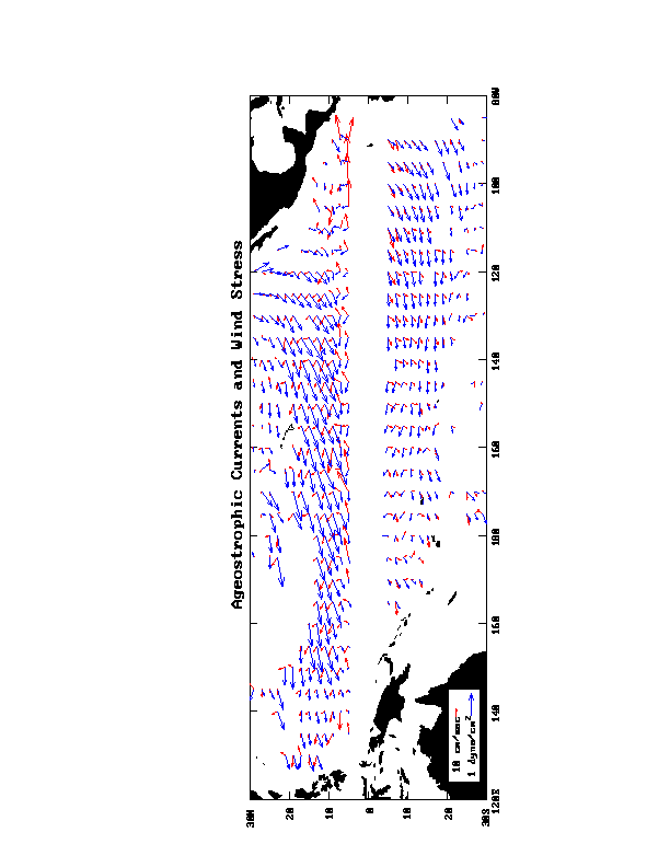
Using surface drifters which report their
positions via satellite, Ralph and Niiler (1997) have mapped
the average flow at 15 meters depth in the Pacific. When they
subtract the fairly well-known large-scale geostrophic flow from
their average flow, the resulting flow is indeed
to the right of the wind in the northern hemisphere and to the
left in the southern hemisphere, which substantiates the
idea of Ekman transport on a large spatial scale (Fig. 15 from E.
Ralph, and based on Ralph and Niiler, 1997).
Winds are highly
variable in general - weather patterns come and go in a
matter of days. However, winds averaged over a season or a year
or many years drive
the large-scale, slowly-changing ocean
circulation. Because the average winds vary in strength and
also in direction over a large scale, the surface layer Ekman flow
varies in strength and direction.
Where the surface flow converges (flows together), there must be
downwelling, and where it diverges (flows apart), there must be
upwelling.
In regions of downwelling, the ocean lying
beneath the surface layer, and down to about 2000 meters depth,
responds with slow equatorward
flow. The reason for this equatorward flow is more or less
angular momentum conservation - as a vertical column of water that
rotates due to the earth's rotation is squashed by downwelling, it must
spin more slowly. To spin more slowly it moves towards the
equator where the amount of earth's rotation which projects
onto the vertical column is lower.
Such slow equatorward flow
is found in the subtropics (20° to 40° from the equator)
where there are westerlies at higher latitude and easterly
trades at lower latitude. This slow equatorward flow is fed
from the western boundary, by eastward flow at latitudes of
30° to 50°. The equatorward flow returns to the
western boundary at latitudes of about 15° to 30° in
the northern hemisphere and from 30°S to the equator in the
southern hemisphere. The western boundary current which
feeds this circulation in the northern hemisphere is the
Kuroshio. In the southern hemisphere it is the East
Australia Current.
In regions of upwelling, the underlying
ocean flow is poleward, away from the equator. This occurs
at high latitudes (greater than 50°) and also in the
narrow band under the Intertropical Convergence Zone at
about 5° to 10°N. The result is a counterclockwise
circulation. In the northern North Pacific, the western
boundary current which feeds this gyre is the Oyashio. In
the tropics north of the equator,
the currents are nearly due east-west but they do have a slight
counterclockwise
gyre configuration and a western boundary current. The currents
in this tropical gyre are the North Equatorial Countercurrent,
which flows eastward on the southern side of this cell, and
the southern part of the North Equatorial Current, which
flows westward on the northern side of this cell. Its
western boundary current is the Mindanao Current.
Directly on the equator, the effect of rotation on the circulation
vanishes, and so these concepts of geostrophic and Ekman flow do not
apply. At the equator, the easterly trade winds push the
surface water directly from east to west. This water piles
up gently in the western Pacific (0.5 meters higher
there than in the eastern Pacific). Because it is higher in
the west than in the east, there is a pressure difference
which causes the flow just beneath the surface layer to be
eastward. This strong eastward flow is the Equatorial
Undercurrent.
The alternating eastward and westward jets found below the
Equatorial Undercurrent on the equator die out about
2° from the equator.
Their cause has not been clearly identified.
However the theory of very slow
waves on the equator, which move water from side to side
much more than the up and down of surface waves, shows us
that equatorial
waves have much more complicated (reversing) vertical structure
than waves off the equator. It is expected that this complex
structure for the very slow waves with very long east-west
wavelengths translates to complex structure in the
mean currents.
Also occurring very close to the equator is
northward Ekman transport north of the equator and southward
Ekman transport south of the equator, due to the easterly trade
winds (blowing from east to west). This causes upwelling
right at the equator.
Along the equator just below the
surface, waters in the east are colder than in the
west. This is partially a result of the rising of the
Equatorial Undercurrent from west to east in response to
upwelling. Upwelling in the eastern Pacific thus accesses
much cooler water than in the western Pacific, and as a
result the surface waters in the east are colder than in the
west.
Steady trade winds, which cause equatorial upwelling,
are more prevalent in the east than in the west. There is
seasonality in the winds, and equatorial upwelling is weaker
in the northern winter and spring, giving rise to mini-El
Nino conditions (section 6)
each year in the eastern equatorial Pacific.
When the trade
winds weaken or even reverse, the flow of water westward at
the equator weakens or reverses and upwelling weakens or
stops. Surface waters in the eastern Pacific warm
significantly since upwelling is no longer bringing the cool
waters to the surface. The deep warm pool in the western
Pacific thins as its water sloshes eastward along the
equator in the absence of the trade winds which maintain it.
Ocean water density is a function of temperature and salinity,
and so can be changed through heating/cooling and evaporation/
precipitation. The resulting density changes can drive circulation,
but density-driven flow is much weaker than that driven by the winds.
However, density changes, caused mainly by fluxes at the
sea surface, are the only means of forcing circulation
where the indirect effect of wind forcing vanishes, as in the ocean deeper
than about 2000 meters.
In the upper ocean, even though density fluxes do not greatly
change the flow, they do
have a major effect on ocean properties
and on the overlying atmosphere, which is heated
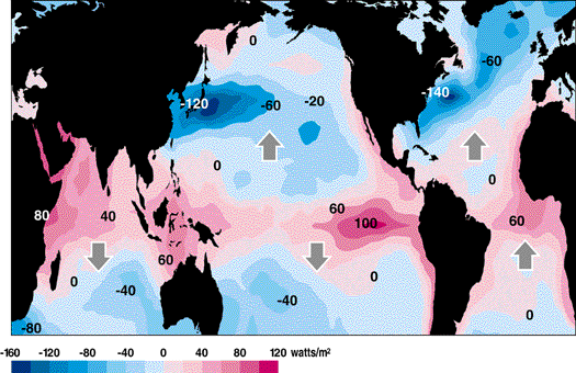
from below by the ocean. The total surface heat flux into
the ocean averaged over all years of data (Fig. 16 from Hsiung, 1985)
shows the greatest heating along the equator and in
the western warm pool
region around Indonesia. The units of heating are Watts/m^2,
or energy per unit area. The uncertainty in heating is
about 20 Watts/m^2 and so values lower than this are
not significantly different from zero.
In the subtropics where the western
boundary currents bring warm water to mid-latitudes, there
is strong cooling.
In order to maintain a fairly steady distribution of temperature,
the ocean must transport heat from the areas where it gains heat
to the areas where it loses it. The large arrows in Fig. 16 show
the direction of heat transport in each ocean basin across the latitudes
where the arrows are placed.
In the western warm pool region and all
along the ITCZ there is major convection in the atmosphere,
creating towering clouds. Precipitation in these regions
creates pools of freshened surface waters. At mid-
latitudes, excess evaporation under the atmospheric high
pressure cells creates high salinity surface water. These
waters can be traced by their salinity as they move to below
the sea surface and are carried far by the ocean currents.
Large changes in the climate occur in the tropical Pacific over
the course of three to seven years, as described in the
chapter on climate. This phenomenon is known as El Nino and
encompasses the entire tropical Pacific ocean and
atmosphere. It is a truly coupled interaction between the
atmosphere and ocean. Its effects reach far beyond the
tropical Pacific through connections in the far-ranging
atmospheric circulation.
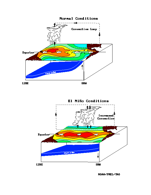
The events that form a typical El
Nino have been described by Rasmussen and Carpenter (1982), and
are illustrated in Fig. 17, from the NOAA/PMEL TAO project
office (McPhaden, 1997).
Philander (1990) provides a textbook summary of El Nino.
A Report to the Nation (NOAA OGP, 1994) provides an excellent
summary as do a number of El Nino websites (see McPhaden, 1997
in the reference list).
During an El Nino, the normal easterly trade winds slacken, as
indicated by a decrease in the atmospheric pressure
difference between the central and western Pacific. (The
pressure difference between Tahiti and Darwin, Australia,
called the Southern Oscillation Index, is often taken as a
measure of El Nino, hence the commonly-used name El
Nino/Southern Oscillation.)
The weakened trade winds result
in reduced westward flow at the equator which leads to a
draining of the western warm pool towards the east.
Equatorial ocean upwelling is reduced, which results in
warmer sea surface temperatures in the eastern Pacific. As
the western warm pool cools slightly and the central and
eastern equatorial Pacific warm, this further reduces the
strength of the tradewinds, in other words, providing a
positive feedback. The large atmospheric convection cell
over Indonesia moves eastward. This results in drought in
the western Pacific, including over Indonesia and Australia,
and increased rainfall in the central and eastern Pacific,
for instance at Christmas Island, the Galapagos and Ecuador.
The warm water in the eastern Pacific spreads to the
eastern boundary and splits to flow north and south there.
Upwelling off northern Peru might weaken, or just draw on
the warm, nutrient-poor equatorial water. The result is a
decline in production in this important fisheries area. If
the El Nino is particularly strong, its effect in the ocean
can reach as far north as the California coast.
The opposite phase of the El Nino is
called La Nina, characterized by especially strong
tradewinds, a well-developed warm pool in the western
Pacific and cold water at the equator in the central and
eastern Pacific, with strong rainfall in the western
Pacific, little rainfall in the eastern Pacific, and major
fisheries production in the eastern boundary regions.
El Nino affects mid-latitudes through "teleconnections" in the
atmosphere. Changes in the western tropical Pacific
reach far to the northeast and southeast through the atmosphere
and directly affect
climate in the coastal regions of the United States and
South America.
El Nino occurs irregularly, but generally every three to seven years.
Major progress has been made in predicting an El Nino about
one year in advance because the sequence of events in an El Nino is
often the same.
Thus detection of early signs of El Nino, such as the appearance of
warm water in the eastern tropical Pacific or a change in the strength
of the trade winds, often allows prediction of changes in rainfall
and air temperature later in the year throughout the Pacific region.
A major observing network and computer modeling
effort is in place to assist in observing and forecasting El Nino
occurrences (see the website in the reference list under McPhaden, 1997).
The strength of El Nino varies greatly
over an even more irregular time scale of about ten
to thirty years. For instance El Nino's in the 1940's were
strong, followed by several decades of weak events, and then
followed by very strong El Nino's again in the 1980's and
1990's. Long records of El Nino's have been extracted from
the reasonably long pressure records at Tahiti and Darwin,
and from growth and properties of the annual accretion in
coral heads in the tropical Pacific.
This so-called decadal
modulation of El Nino is much less well-understood than El Nino
itself. One way that the decadal pattern differs from El Nino is
that its amplitude is about the same in the northern and southern Pacific
as in the tropics, as opposed to the much more equatorially-trapped El Nino
changes (Zhang et al., 1997). This suggests that there
might be feedbacks which involve a much larger region than
just the tropics, although it could still be a tropically-
dominated mode. Major research
on these ocean-atmosphere feedbacks, which affect much longer
timescales, is being planned for the next decade.
Acknowledgments. We appreciate the assistance and advice provided
by E. D. Stroup. Graphical assistance was supported by the
cooperative agreement
(NA47GP0188) from the National Oceanic and Atmospheric Administration.
Figure 1.
Significant wave height in meters for two 10-day
periods typifying northern winter and northern summer conditions:
(a) January, 1995
and (b) July, 1995.
The figures are modified from online gif images from
the Topex/Poseidon satellite altimeter measurements and
are based on observations collected over a 10-day period.
Courtesy Jet Propulsion Laboratory.
Copyright (c) California Institute of Technology, Pasadena, CA. All rights
reserved.
Figure 2.
(a) Amplitude (in cm) and (b) phase of the main
diurnal (once per day) tide
for the Pacific Ocean; this tidal component is referred to
as the K1 tide. In (b), the contours show the time of
high water associated with this tidal component. In most of the
North Pacific the K1 tide progresses in a counterclockwise direction
around the amphidrome found at (15N, 175E). In the South Pacific,
the tide progresses
in a clockwise direction around the amphidromes.
Figure 3.
Tidal currents (cm/sec) at semi-diurnal (red) and
diurnal (blue) periods for (a) the Hawaiian Islands and (b) Oahu (gray
area in (a)).
The major axes of the ellipses
show the most probable orientation and strength of tidal currents.
Data were taken variously from 1960 to 1995, and were provided
by the University of Hawaii, Hawaii Institute of Geophysics; National
Ocean Data
Center, NOAA, and Science Applications Internal Corporation.
(From Flament et al., 1997).
Figure 4.
Third wave of a tsunami from the Aleutian Islands running
ashore
on the island of Oahu, Hawaii, in 1957. Runup here is about two meters.
(NOAA photo)
Figure 5.
Travel times (hours) for the tsunami resulting
from the magnitude 9.4 Chile earthquake of 1960.
Figure 6.
Surface temperature (annual mean) (°C).
The gridded data are freely available from the National
Oceanic and Atmospheric Administration atlas (Levitus et al., 1994b).
Figure 7.
Surface
salinity (annual mean). Data sources as in Figure 6 (Levitus et al.,
1994a).
Figure 8.
(a) Vertical section of temperature (°C) and
(b) vertical section of salinity along the
equator, collected on a French expedition in January - March, 1991
(Reverdin et al., 1991).
Figure 9.
(a) East-west currents in the central Pacific.
Positive numbers are eastward flows in cm/sec.
These velocities were computed from 43 separate cross-sections
at 150 to 158°W, collected over a period of 17 months in 1979-1980.
(b) Average temperature from these cruises.
(Both from Wyrtki and Kilonsky, 1984.)
Figure 10.
Vertical section of potential temperature (°C)
along 150°W from data
collected in 1991-1993 as part of the World Ocean Circulation
Experiment. Data north of Hawaii were collected in 1984
(Talley et al., 1991).
Potential temperature is the temperature a parcel of water would
have if moved to the sea surface with no change in heat content,
and is lower than measured temperature since temperature increases
when water is compressed due to the high pressure in the ocean.
Figure 11.
Vertical section of salinity along 150°W.
Data sources are the same as for Figure 10.
Figure 12.
Nitrate (umol/l) near the sea surface. Gridded data are from
the NOAA atlas (Conkright et al., 1994). A similar map was
published by Levitus et al. (1993).
Figure 13.
Schematic of the surface circulation of the
Pacific (after Tabata, 1975).
Figure 14.
Schematic of the surface circulation of the western tropical
Pacific (Fine et al., 1996).
Surface current abbreviations (solid arrows):
NEC (North Equatorial Current), NECC (North Equatorial
Countercurrent), SEC (South Equatorial Current), MC (Mindanao Current),
NGCC (New Guinea Coastal Current), EAC (East Australia Current),
ME (Mindanao Eddy), HE (Halmahera Eddy).
Subsurface current abbreviations (dashed arrows): MUC (Mindanao
Undercurrent), NGCUC (New Guinea Coastal Undercurrent),
NSCC (North Subsurface Countercurrent), EUC (Equatorial
Undercurrent), SSC (South Subsurface Countercurrent).
The light dashed boundary south of 10S shows the limit of the
AAIW (Antarctic Intermediate Water), which is the low salinity
subsurface layer seen at about 700-800 meters depth in Fig. 11.
Figure 15.
Annual average surface wind stress (blue arrows in stress/unit area)
and the average near-surface flow (red arrows in cm/sec)
which arises directly in response to the winds. The surface wind
stress acts on just the very surface of the ocean. This force
is transmitted through friction into the surface layer, and the
direction of the stress turns with depth due to the rotation of the
earth. The direct stress disappears at a depth of only
about 50 meters. The resulting flow in the top 50 meters or so of
the ocean is to the right of the surface wind in the northern
hemisphere and to the left in the southern hemisphere and is called
the Ekman transport. The red arrows in the figure are the average
velocity based on thousands of satellite-tracked surface drifters
after the average flow resulting from the ocean's pressure field
(geostrophic flow) is subtracted out. (figure from E. Ralph)
Figure 16.
Annual mean heat flux from the atmosphere to the
ocean, based on Hsiung (1985).
Units are Watts meter^-2, which is an energy per unit area.
Positive numbers (red) indicate that the ocean is being heated.
The large arrows show the direction of total ocean heat
transport from the surface to the bottom of the ocean across
major ocean basins; this heat is transported by meandering
currents. (The northward arrow in the South Atlantic is correct
and is due to the strong global overturning cell in which
warm water from the South Atlantic is replenished by cold
water from the North Atlantic.)
Contributing to the heat flux into the ocean, in order of
relative importance, are the incoming radiation
from the sun, loss of heat due to energy used in evaporation,
loss of heat due to blackbody radiation, and loss of heat
due to the difference in temperature at the surface between the water
and overlying air.
Figure 17.
Schematic of the relations between the ocean's
temperature structure, surface winds (broad open arrows),
ocean upwelling (small black arrows),
atmospheric convection (up and down black arrows and dashed cells) and
cloud patterns in the tropical Pacific during normal conditions
and during an El Nino. (This figure is from the
TAO Project Office, Dr. Michael J. McPhaden, Director, and is
available on the El Nino theme page of the NOAA/Pacific Marine
Environmental Laboratory - http://www.pmel.noaa.gov/toga-tao/el-nino,
where one can find much more information about El Nino as well
as current conditions and forecasts.)
Conkright, M. E., S. Levitus and T. P. Boyer. 1994.
World Ocean atlas. Vol. 1,
Nutrients, NOAA Atlas NESDIS, 162 pp.
[Available from NODC/NOAA, E/OC5, 1315 East-West Highway, Silver
Spring, MD 20910.]
Fine, R.A., Lukas, R., Bingham, F.M., Warner, M.J. and R.H. Gammon. 1994.
The Western Equatorial Pacific: A Water Mass Crossroads. J. Geophys. Res.,
99:25063-25080.
Firing, E. 1989. Mean Zonal Currents Below 1500 m Near the Equator,
159W. J. Geophys. Res., 94:2023-2028.
Flament, P., Kennan, S. , Lumpkin, R. , Sawyer, M. and E.D.
Stroup, 1997. "The Ocean Atlas of Hawa ii", 24"x36" poster and
copyrighted website:
http:/satftp.soest.hawaii.edu/atlas.
University of Hawaii.
Graham, N.E. and T.P. Barnett. 1987. Sea Surface Temperature, Surface
Wind Divergence, and Convection over Tropical Oceans. Science,
238:657-659.
Hofmann, E. E., Busalacchi, A.J. and J. J. O'Brien. 1981.
Wind generation of the Costa Rica Dome. Science, 214:552-554.
Hsiung, J. 1985. Estimates of Global Oceanic Meridional Heat Transport.
J. Phys. Oceanogr., 15:1405-1413.
Iida, K., D.C. Cox, and G. Pararas-Carayannis, 1967, Preliminary
catalog of tsunamis occurring in the Pacific Ocean, Hawaii Institute of
Geophysics Pub. HIG-67-10, University of Hawaii, Honolulu, 274pp.
Johnson, G.C. and J.M. Toole. 1993. Flow of Deep and Bottom Waters in the
Pacific at 10°N. Deep-Sea Research, 40:371-394.
Knauss, J.A. 1960. Measurements of the Cromwell Current. Deep-Sea
Research, 6:265-286.
Knauss, J. A., 1997. Introduction to Physical Oceanography. Second
Edition. Prentice-Hall, New Jersey. 309 pp.
Lander, J.F., and P.A. Lockridge, 1989, United States tsunamis
(including U.S. possessions) 1690-1988, Publication 41-2, National
Geophysical Data Center, Boulder, CO., 265pp.
Levitus, S. and T. P. Boyer. 1994a.
World Ocean atlas. Vol. 3,
Salinity, NOAA Atlas NESDIS, 111 pp.
[Available from NODC/NOAA, E/OC5, 1315 East-West Highway, Silver
Spring, MD 20910.]
Levitus, S. and T. P. Boyer. 1994b.
World Ocean atlas. Vol. 4,
Temperature, NOAA Atlas NESDIS, 129 pp.
[Available from NODC/NOAA, E/OC5, 1315 East-West Highway, Silver
Spring, MD 20910.]
Levitus, S., Conkright, M.E., Reid, J.L. , Najjar, R.G. and A. Mantyla.
1993. Distribution of Nitrate, Phosphate and Silicate in the World Oceans.
Prog. Oceanogr., 31:245-273.
Lindstrom, E., Lukas, R., Fine, R., Firing, E., Godfrey, S., Meyers, G. and
M. Tsuchiya. 1987. The Western Equatorial Pacific Ocean Circulation Study.
Nature, 330:533-537.
Lukas, R. and E. Lindstrom. 1991. The Mixed Layer of the Western
Equatorial Pacific Ocean. J. Geophys. Res., 96:3343-3357.
McPhaden, M. J. 1997. NOAA/PMEL TAO Project Office: El Nino theme page.
Website: http://www.pmel.noaa.gov/toga-tao/el-nino.
National Oceanographic and Atmospheric Administration (NOAA)
Office of Global Programs. 1994. El Nino and Climate Prediction.
Reports to the Nation on our Changing Planet. 25 pp.
Neshyba, S., 1987. Oceanography: Perspectives on a Fluid Earth. John
Wiley and Sons, New York. 506 p.
Philander, S.G. 1990. El Nino, La Nina, and the Southern Oscillation.
Academic Press, Inc., San Diego, California. 293 pp.
Pickard, G.L. and W.J. Emery. 1990. Descriptive Physical Oceanography:
An Introduction. Pergamon Press, Oxford, England. 320 pp.
Price, J.M., Vanwoert, M.L. and M. Vitousek. 1994. On the Possibility of
a Ridge Current Along the Hawaiian Islands. J. of Geophys.
Res., 99:14101-14111.
Ralph, E. A. and P. P. Niiler, 1997. Wind-driven currents in the
tropical Pacific. J. Phys. Oceanogr., in press.
Ramanathan, V. and W. Collins. 1993. A Thermostat in the Tropics.
Nature, 36, 11:410-411.
Rasmusson, E.M. and T.H. Carpenter. 1982. Variations in Tropical Sea
Surface Temperature and Surface Wind Fields Associated With the Southern
Oscillation/El Nino. Mon. Weather Rev., 110:354-384.
Reid, J.L. 1997. On the Total Geostrophic Circulation of the Pacific
Ocean: Flow Patterns, Tracers and Transports. Submitted Prog. in
Oceanogr.
Reverdin, G., Morliere, A. and E. Gerard. 1991. Compagne
Oceanographique Trans-Pacifique. Paris, France. 341 pp.
Roden, G.I. 1991. Effects of the Hawaiian Ridge Upon Oceanic Flow and
Thermohaline Structure. Deep-Sea Res., 38:623-654.
Roemmich, D., Morris, M.Y. and W.R. Young. 1994. Equatorial Fresh Jets. J.
Phys. Oceanogr., 24:540-558.
Shepard, F.P., G.A. Macdonald, and D.C. Cox. 1950. The tsunami of April
1, 1946, Bulletin of the Scripps Institution of Oceanography of the
University of California, 5:391-470.
Singh, R. 1991. Tsunamis in Fiji and their effects, in Workshop on
Coastal Processes in the South Pacific Island Nations, SOPAC (U.N.
South Pacific Applied Geoscience Commission), Technical Bulletin 7:
107-120.
Tabata, S. 1975. The general circulation of the Pacific Ocean and a brief
account of the oceanographic structure of the North Pacific Ocean. Part I -
circulation and volume transports. Atmosphere, 13:133-168.
Talandier, J. 1993. Le volcanisme et la sismicit, in Atlas de la
Polynsie Franaise, ORSTOM (Inst. francais de recherche scientifique pour
le developpement en cooperation, Dept. en Territoires d'Outre-Mer), Paris,
maps 26-27.
Talley, L.D. and R.A. deSzoeke. 1986. Spatial fluctuations north of the
Hawaiian Ridge. J. Phys. Oceanogr., 16:981-984.
Talley, L.D., Joyce, T.M. and R.A. deSzoeke. 1991. Transpacific Sections
at 47N and 152W: Distribution of Properties. Deep-Sea Research,
38:S63-S82.
Tomczak, M. and J.S. Godfrey. 1994. Regional Oceanography: An
Introduction. Pergamon Press, England. 422 pp.
Tsuchiya, M. 1968. Upper Waters of the Intertropical Pacific Ocean. The
Johns Hopkins Press, Baltimore. 50 pp.
Tsuchiya, M., Lukas, R., Fine, R.A., Firing, E. and E. Lindstrom. 1989.
Source Waters of the Pacific Equatorial Undercurrent. Prog. Oceanogr.,
23:101-147.
Worthington, L.V. 1981. The Water Masses of the World Ocean: Some
Results of a Fine-Scale Census. Evolution of Physical Oceanography:
Scientific Surveys in Honor of Henry Stommel, ed. Warren, B.A. and C. Wunsch.
The MIT Press, Cambridge, Massachusetts. 42-69.
Wyrtki, K. and B. Kilonsky. 1984. Mean Water and Current Structure during
the Hawaii-to-Tahiti Shuttle Experiment. J. Phys. Oceanogr., 14:242-254.
Zhang, Y, Wallace, J. M. and D. S. Battisti. 1997.
ENSO-like interdecadal variability: 1900-93. J. Climate, 10, 1004-1020.
1. Introduction
2. Surface waves, tides and tsunamis
The ocean is constantly moving. Surface gravity waves are what
catch our eyes - they are created by wind blowing over the sea
surface either nearby (small or choppy waves)
or far away (long ocean swell). We are also usually aware of the daily
or twice daily cycle of tides, as beaches and reefs are successively
covered and exposed. At times of the year when tides are very high
and a storm creates large surface waves, "storm surges"
can become a problem in low-lying coastal areas.
Once in a long while, residents of coastal
areas may be affected by a large and long-period wave called
a "tsunami", generated by an earthquake either nearby or very far away.
These three types of waves, which have periods of minutes to
hours, are described in this section.
2.a. Surface waves
2.b. Tides
Tides are produced by the gravitational attraction between the
earth and the moon and sun, and the centrifugal force on the
earth as it moves around the center of gravity between it and the
moon/sun. Since the orbits of these
bodies are regular, tides are regular, and
are in fact the only part of the ocean's motion which
can be exactly predicted. A full description
of the tidal potential is beyond the scope of this text - the
reader is referred to texts such as those of Knauss (1997) or
Neshyba (1987).
2.c. Tsunamis
3. Temperature and salinity distribution in the tropical Pacific
The temperature of the sea has a large effect on local climate -
what can grow in the water and on nearby land,
fog and precipitation, production of hurricanes, and so on.
The salt in seawater is what most obviously distinguishes it
from freshwater, and affects the ecology of coastal lagoons,
tidal flats, and river mouths. The salt has less overt influence
than temperature on climate, but it does affect how deeply the
surface layer of the ocean can mix and hence on the
temperature of the surface layer, and thus has a subtle
effect on climate.
3.a. Temperature.
3.b. Salinity.
4. Ocean circulation in the tropical Pacific
In section 2 we described the ocean motions which are clear to a
person on shore looking at the ocean.
The ocean also has
much slower motion - ocean currents which vary slowly over weeks
to months, years and many decades. These affect navigation. Currents
are also
important in moving water from one place to another, which
redistributes heat, salt, and higher and lower nutrients.
4.a. Surface circulation.
4.b. Subsurface equatorial circulation
The currents below the sea surface seem of less immediate importance
to man, as they do not affect sailing or have an obvious effect
on local ocean surface conditions such as temperature.
However, the surface and deeper flows are strongly coupled to each
other. It has become clear in recent years that successful computer
models of the ocean circulation must include the flow below the surface,
all the way down to the ocean bottom, where undersea rises and mountains
strongly steer the bottom currents.
4.c. Deep circulation
4.d. Circulation near islands and island groups
5. Forcing of the circulation
All movement of ocean water must be generated by some force. Surface
waves are created by the wind blowing over the sea surface and catching
on smaller waves to make larger ones. Tides are created by the
gravitational pull between the earth and the moon and sun.
Tsunamis are created by undersea earthquakes. Ocean currents and large
eddies are created by the winds acting much more indirectly than for
surface waves, and also by cooling and evaporation which can cause the
water to overturn.
5.a. Wind forcing of non-equatorial flow
5.b. Wind-driven circulation at the equator.
5.c. Response to changing winds in the tropics
5.d. Heating/cooling and evaporation/precipitation
6. Climate variability in the tropical Pacific
Figures.
References